Potejamel geodata
Potejamel (Hidalgo) is a populated place; located in Mexico in America/Mexico_City (GMT-6) time zone. With population of 507 people, there are 16589 cities with bigger population in this country. Compared to other cities in Mexico, 79.7% of cities are located further ↓South; 56.1% of cities are located further ←West and 77.4% of cities have higher elevation than Potejamel. Note1


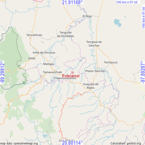
Potejamel GPS coordinates[2]
21° 15' 28.332" North, 98° 35' 45.564" West
| Map corner | latitude | longitude |
|---|---|---|
| Upper-left | 21.91168°, | -99.29912° |
| Center: | 21.25787°, | -98.59599° |
| Lower-right: | 20.60114°, | -97.89287° |
| Map W x H: | 145.7×145.7 km | = 90.5×90.5mi |
| max Lat: | 32.7° ⇑20.3% North |
| Potejamel: | 21.25787° |
| min Lat: | ⇓79.7% South 14.53588° |
| min Long | Potejamel | max Long |
| -117.105° | -98.59599° | -86.73105° |
| W 56.1%⇐ | ⇒43.9% E |
Elevation
Elevation of Potejamel is 144 m = 472 ft, and this is 1109.7 m = 3641 ft below average elevation for this country.
| Max E: |
3497 m = 11473 ft | 77.4% |
| Avg. | 1253.7 m = 4113 ft | |
| Potejamel | 144 m = 472 ft | |
Min E: |
-1 m = -3 ft | 22.6% |
See also: Mexico elevation on elevation.city.
Geographical zone
Potejamel is located in North Torrid zone (between Equator and Tropic of Cancer). Distance of this Northern Tropic circle is 242.3 km =150.6 mi to North.| Distance of | km | miles | from Potejamel |
|---|---|---|---|
| North Pole | 7643.4 | 4749.4 | to North |
| Arctic Circle | 5037.5 | 3130.2 | to North |
| Tropic Cancer | 242.3 | 150.6 | to North |
| Equator | 2363.7 | 1468.7 | to South |


Nearby cities:
15 places around Potejamel: (largest is in red/bold)
• Ahuatitla
12.6 km =7.8 mi,  215°
215°
• Chapulhuacanito
9.4 km =5.8 mi,  234°
234°
• Cochiscuatitla
7.5 km =4.7 mi,  141°
141°
• Cojolapa
12 km =7.5 mi,  250°
250°
• Cruztitla
8.4 km =5.2 mi,  102°
102°
• El Palmito
11.7 km =7.3 mi,  265°
265°
• Huitzitzilingo
11.4 km =7.1 mi,  213°
213°
• Las Chacas
9 km =5.6 mi,  125°
125°
• Piedra Hincada
4.4 km =2.7 mi,  67°
67°
• San Felipe Orizatlán
9.7 km =6 mi,  187°
187°
• Santa Cruz
12.5 km =7.8 mi,  122°
122°
• Tezontla
10.6 km =6.6 mi,  259°
259°
• Totonicapa
11.1 km =6.9 mi,  179°
179°
• Zohuala
11.9 km =7.4 mi, 104°
• Ámaxac
13.1 km =8.1 mi,  111°
111°
Sources, notices
• [Note1] Compared only with cities in Mexico existing in our database
• [Src1] Map data: © OpenStreetMap contributors (CC-BY-SA)
• [Src2] Other city data from geonames.org with taken over terms of usage.
• [Src3] Geographical zone / Annual Mean Temperature by Robert A. Rohde @ Wikipedia
