Ojo de Agua geodata
Ojo de Agua (Veracruz) is a populated place; located in Mexico in America/Mexico_City (GMT-6) time zone. With population of 650 people, there are 13331 cities with bigger population in this country. Compared to other cities in Mexico, 78.9% of cities are located further ↑North; 83.6% of cities are located further ←West and 82.7% of cities have higher elevation than Ojo de Agua. Note1


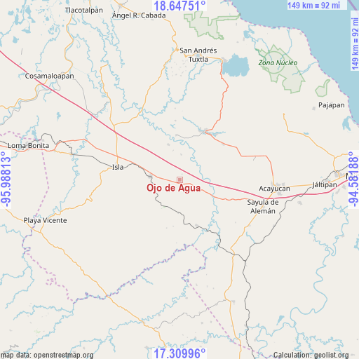
Ojo de Agua GPS coordinates[2]
17° 58' 48" North, 95° 17' 6" West
| Map corner | latitude | longitude |
|---|---|---|
| Upper-left | 18.64751°, | -95.98813° |
| Center: | 17.98°, | -95.285° |
| Lower-right: | 17.30996°, | -94.58188° |
| Map W x H: | 148.7×148.7 km | = 92.4×92.4mi |
| max Lat: | 32.7° ⇑78.9% North |
| Ojo de Agua: | 17.98° |
| min Lat: | ⇓21.1% South 14.53588° |
| min Long | Ojo de Agua | max Long |
| -117.105° | -95.285° | -86.73105° |
| W 83.6%⇐ | ⇒16.4% E |
Elevation
Elevation of Ojo de Agua is 63 m = 207 ft, and this is 1190.7 m = 3906 ft below average elevation for this country.
| Max E: |
3497 m = 11473 ft | 82.7% |
| Avg. | 1253.7 m = 4113 ft | |
| Ojo de Agua | 63 m = 207 ft | |
Min E: |
-1 m = -3 ft | 17.3% |
See also: Mexico elevation on elevation.city.
Geographical zone
Ojo de Agua is located in North Torrid zone (between Equator and Tropic of Cancer). Distance of this Northern Tropic circle is 606.7 km =377 mi to North.| Distance of | km | miles | from Ojo de Agua |
|---|---|---|---|
| North Pole | 8007.9 | 4975.9 | to North |
| Arctic Circle | 5402 | 3356.6 | to North |
| Tropic Cancer | 606.7 | 377 | to North |
| Equator | 1999.2 | 1242.2 | to South |


Nearby cities:
15 places around Ojo de Agua: (largest is in red/bold)
• Aguapinole (Cuapinole)
18.2 km =11.3 mi,  92°
92°
• Angostura
13.7 km =8.5 mi,  182°
182°
• Casas Viejas
3 km =1.9 mi,  74°
74°
• Cuatotolapan Viejo
18.6 km =11.6 mi,  6°
6°
• El Blanco
10.5 km =6.5 mi,  2°
2°
• Estación Juanita
20.3 km =12.6 mi,  159°
159°
• Huayacanes
6.9 km =4.3 mi,  173°
173°
• Juan Rodríguez Clara
12.3 km =7.6 mi,  276°
276°
• La Cañada
12.5 km =7.8 mi,  346°
346°
• La Lima
14.5 km =9 mi,  114°
114°
• Loma de Hujuapan
8.4 km =5.2 mi,  64°
64°
• Loma de los Ingleses
21.3 km =13.2 mi,  33°
33°
• Los Tigres (San Marcos)
12.1 km =7.5 mi,  214°
214°
• Nopalapan
15.5 km =9.6 mi,  341°
341°
• San Juan Evangelista
18.6 km =11.6 mi,  124°
124°
Sources, notices
• [Note1] Compared only with cities in Mexico existing in our database
• [Src1] Map data: © OpenStreetMap contributors (CC-BY-SA)
• [Src2] Other city data from geonames.org with taken over terms of usage.
• [Src3] Geographical zone / Annual Mean Temperature by Robert A. Rohde @ Wikipedia
