Juan Rodríguez Clara geodata
Juan Rodríguez Clara (Veracruz) is a seat of a second-order administrative division; located in Mexico in America/Mexico_City (GMT-6) time zone. With population of 14,628 people, there are 661 cities with bigger population in this country. Compared to other cities in Mexico, 78.7% of cities are located further ↑North; 83.3% of cities are located further ←West and 77.4% of cities have higher elevation than Juan Rodríguez Clara. Note1
Current local time in Juan Rodríguez Clara:
08:35 AM, WednesdayDifference from your time zone: hours


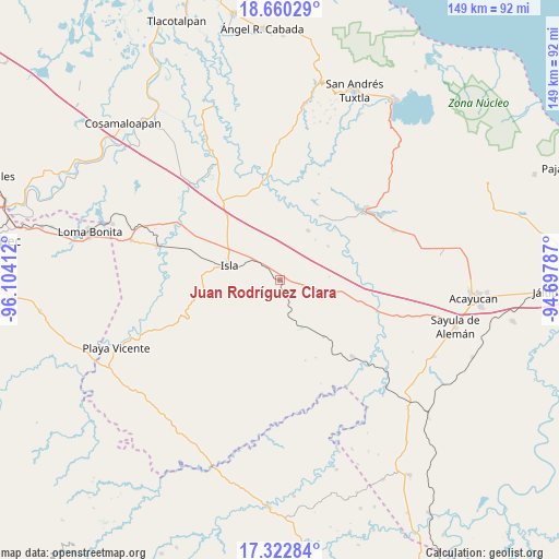
Juan Rodríguez Clara GPS coordinates[2]
17° 59' 34.188" North, 95° 24' 3.564" West
| Map corner | latitude | longitude |
|---|---|---|
| Upper-left | 18.66029°, | -96.10412° |
| Center: | 17.99283°, | -95.40099° |
| Lower-right: | 17.32284°, | -94.69787° |
| Map W x H: | 148.7×148.7 km | = 92.4×92.4mi |
| max Lat: | 32.7° ⇑78.7% North |
| Juan Rodríguez Clara: | 17.99283° |
| min Lat: | ⇓21.3% South 14.53588° |
| min Long | Juan Rodríguez | max Long |
| -117.105° | -95.40099° | -86.73105° |
| W 83.3%⇐ | ⇒16.7% E |
Elevation
Elevation of Juan Rodríguez Clara is 143 m = 469 ft, and this is 1110.7 m = 3644 ft below average elevation for this country.
| Max E: |
3497 m = 11473 ft | 77.4% |
| Avg. | 1253.7 m = 4113 ft | |
| Juan Rodríguez Clara | 143 m = 469 ft | |
Min E: |
-1 m = -3 ft | 22.6% |
See also: Mexico elevation on elevation.city.
Geographical zone
Juan Rodríguez Clara is located in North Torrid zone (between Equator and Tropic of Cancer). Distance of this Northern Tropic circle is 605.3 km =376.1 mi to North.| Distance of | km | miles | from Juan Rodríguez Clara |
|---|---|---|---|
| North Pole | 8006.4 | 4974.9 | to North |
| Arctic Circle | 5400.6 | 3355.8 | to North |
| Tropic Cancer | 605.3 | 376.1 | to North |
| Equator | 2000.6 | 1243.1 | to South |


Nearby cities:
15 places around Juan Rodríguez Clara: (largest is in red/bold)
• Angostura
19.1 km =11.9 mi,  142°
142°
• Casas Viejas
15.2 km =9.4 mi,  92°
92°
• Cuatotolapan Viejo
22.2 km =13.8 mi,  39°
39°
• El Blanco
15.6 km =9.7 mi,  54°
54°
• El Paraíso
12.7 km =7.9 mi,  289°
289°
• Huayacanes
15.4 km =9.6 mi,  122°
122°
• Isla
14.1 km =8.8 mi, 285°
• La Cañada
14.2 km =8.8 mi, 40°
• La Unión
14.3 km =8.9 mi,  331°
331°
• Loma de Hujuapan
20 km =12.4 mi,  83°
83°
• Los Tigres (San Marcos)
12.6 km =7.8 mi,  154°
154°
• Mazoco
23.8 km =14.8 mi, 289°
• Nopalapan
15.2 km =9.4 mi,  29°
29°
• Ojo de Agua
12.3 km =7.6 mi,  96°
96°
• Totoloche
16.6 km =10.3 mi,  235°
235°
Sources, notices
• [Note1] Compared only with cities in Mexico existing in our database
• [Src1] Map data: © OpenStreetMap contributors (CC-BY-SA)
• [Src2] Other city data from geonames.org with taken over terms of usage.
• [Src3] Geographical zone / Annual Mean Temperature by Robert A. Rohde @ Wikipedia
