Huayacanes geodata
Huayacanes (Veracruz) is a populated place; located in Mexico in America/Mexico_City (GMT-6) time zone. With population of 1,279 people, there are 6777 cities with bigger population in this country. Compared to other cities in Mexico, 79.5% of cities are located further ↑North; 83.7% of cities are located further ←West and 76% of cities have higher elevation than Huayacanes. Note1


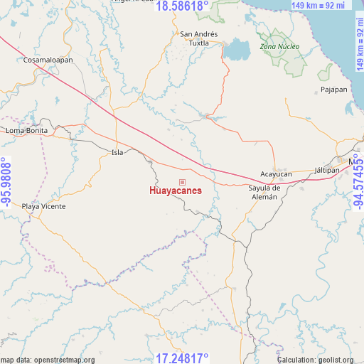
Huayacanes GPS coordinates[2]
17° 55' 6.384" North, 95° 16' 39.612" West
| Map corner | latitude | longitude |
|---|---|---|
| Upper-left | 18.58618°, | -95.9808° |
| Center: | 17.91844°, | -95.27767° |
| Lower-right: | 17.24817°, | -94.57455° |
| Map W x H: | 148.8×148.8 km | = 92.5×92.5mi |
| max Lat: | 32.7° ⇑79.5% North |
| Huayacanes: | 17.91844° |
| min Lat: | ⇓20.5% South 14.53588° |
| min Long | Huayacanes | max Long |
| -117.105° | -95.27767° | -86.73105° |
| W 83.7%⇐ | ⇒16.3% E |
Elevation
Elevation of Huayacanes is 188 m = 617 ft, and this is 1065.7 m = 3496 ft below average elevation for this country.
| Max E: |
3497 m = 11473 ft | 76% |
| Avg. | 1253.7 m = 4113 ft | |
| Huayacanes | 188 m = 617 ft | |
Min E: |
-1 m = -3 ft | 24% |
See also: Mexico elevation on elevation.city.
Geographical zone
Huayacanes is located in North Torrid zone (between Equator and Tropic of Cancer). Distance of this Northern Tropic circle is 613.6 km =381.3 mi to North.| Distance of | km | miles | from Huayacanes |
|---|---|---|---|
| North Pole | 8014.7 | 4980.1 | to North |
| Arctic Circle | 5408.8 | 3360.9 | to North |
| Tropic Cancer | 613.6 | 381.3 | to North |
| Equator | 1992.3 | 1238 | to South |


Nearby cities:
15 places around Huayacanes: (largest is in red/bold)
• Aguapinole (Cuapinole)
18.4 km =11.4 mi,  71°
71°
• Angostura
6.9 km =4.3 mi,  191°
191°
• Bellaco
17.8 km =11.1 mi,  144°
144°
• Casas Viejas
7.9 km =4.9 mi,  15°
15°
• Chapopoapan
20.3 km =12.6 mi,  88°
88°
• El Blanco
17.3 km =10.7 mi,  358°
358°
• Estación Juanita
13.7 km =8.5 mi,  152°
152°
• Juan Rodríguez Clara
15.4 km =9.6 mi,  302°
302°
• La Cañada
19.3 km =12 mi,  348°
348°
• La Lima
12.5 km =7.8 mi, 85°
• Loma de Hujuapan
12.5 km =7.8 mi,  33°
33°
• Los Tigres (San Marcos)
8.2 km =5.1 mi,  247°
247°
• Ojo de Agua
6.9 km =4.3 mi, 353°
• Rancho Nuevo
20.9 km =13 mi, 92°
• San Juan Evangelista
15 km =9.3 mi,  103°
103°
Sources, notices
• [Note1] Compared only with cities in Mexico existing in our database
• [Src1] Map data: © OpenStreetMap contributors (CC-BY-SA)
• [Src2] Other city data from geonames.org with taken over terms of usage.
• [Src3] Geographical zone / Annual Mean Temperature by Robert A. Rohde @ Wikipedia
