El Blanco geodata
El Blanco (Veracruz) is a populated place; located in Mexico in America/Mexico_City (GMT-6) time zone. With population of 1,120 people, there are 7751 cities with bigger population in this country. Compared to other cities in Mexico, 77.8% of cities are located further ↑North; 83.7% of cities are located further ←West and 85.5% of cities have higher elevation than El Blanco. Note1


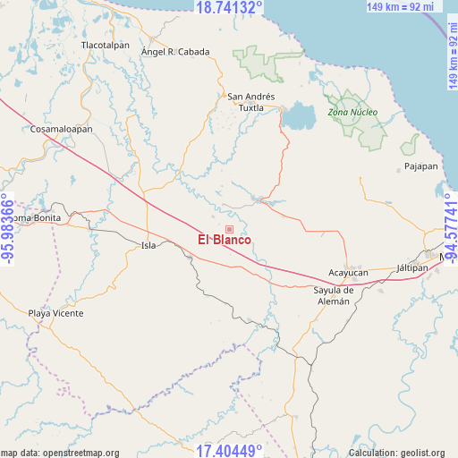
El Blanco GPS coordinates[2]
18° 4' 27.048" North, 95° 16' 49.908" West
| Map corner | latitude | longitude |
|---|---|---|
| Upper-left | 18.74132°, | -95.98366° |
| Center: | 18.07418°, | -95.28053° |
| Lower-right: | 17.40449°, | -94.57741° |
| Map W x H: | 148.6×148.6 km | = 92.3×92.3mi |
| max Lat: | 32.7° ⇑77.8% North |
| El Blanco: | 18.07418° |
| min Lat: | ⇓22.2% South 14.53588° |
| min Long | El Blanco | max Long |
| -117.105° | -95.28053° | -86.73105° |
| W 83.7%⇐ | ⇒16.3% E |
Elevation
Elevation of El Blanco is 41 m = 135 ft, and this is 1212.7 m = 3979 ft below average elevation for this country.
| Max E: |
3497 m = 11473 ft | 85.5% |
| Avg. | 1253.7 m = 4113 ft | |
| El Blanco | 41 m = 135 ft | |
Min E: |
-1 m = -3 ft | 14.5% |
See also: Mexico elevation on elevation.city.
Geographical zone
El Blanco is located in North Torrid zone (between Equator and Tropic of Cancer). Distance of this Northern Tropic circle is 596.3 km =370.5 mi to North.| Distance of | km | miles | from El Blanco |
|---|---|---|---|
| North Pole | 7997.4 | 4969.4 | to North |
| Arctic Circle | 5391.5 | 3350.1 | to North |
| Tropic Cancer | 596.3 | 370.5 | to North |
| Equator | 2009.7 | 1248.8 | to South |


Nearby cities:
15 places around El Blanco: (largest is in red/bold)
• Casas Viejas
10 km =6.2 mi,  166°
166°
• Cuatotolapan Viejo
8.1 km =5 mi,  10°
10°
• El Sauzal
13.6 km =8.5 mi,  26°
26°
• Hueyapan de Ocampo
16 km =9.9 mi,  60°
60°
• Juan Díaz Covarrubias
13.7 km =8.5 mi,  46°
46°
• Juan Rodríguez Clara
15.6 km =9.7 mi,  234°
234°
• La Cañada
3.8 km =2.4 mi,  295°
295°
• La Gloria
13.3 km =8.3 mi,  36°
36°
• Loma de Hujuapan
9.9 km =6.2 mi,  134°
134°
• Loma de los Ingleses
13.4 km =8.3 mi, 56°
• Nopalapan
6.8 km =4.2 mi,  308°
308°
• Norma
14.3 km =8.9 mi,  350°
350°
• Ojo de Agua
10.5 km =6.5 mi,  182°
182°
• San Ángel
17.3 km =10.7 mi,  74°
74°
• Santa Catalina
12.6 km =7.8 mi, 37°
Sources, notices
• [Note1] Compared only with cities in Mexico existing in our database
• [Src1] Map data: © OpenStreetMap contributors (CC-BY-SA)
• [Src2] Other city data from geonames.org with taken over terms of usage.
• [Src3] Geographical zone / Annual Mean Temperature by Robert A. Rohde @ Wikipedia
