Neblinas geodata
Neblinas (Hidalgo) is a populated place; located in Mexico in America/Mexico_City (GMT-6) time zone. With population of 647 people, there are 13375 cities with bigger population in this country. Compared to other cities in Mexico, 78.1% of cities are located further ↓South; 51.6% of cities are located further ←West and 61.3% of cities have higher elevation than Neblinas. Note1


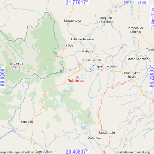
Neblinas GPS coordinates[2]
21° 6' 56.592" North, 98° 55' 24.492" West
| Map corner | latitude | longitude |
|---|---|---|
| Upper-left | 21.77017°, | -99.6266° |
| Center: | 21.11572°, | -98.92347° |
| Lower-right: | 20.45837°, | -98.22035° |
| Map W x H: | 145.9×145.9 km | = 90.7×90.7mi |
| max Lat: | 32.7° ⇑21.9% North |
| Neblinas: | 21.11572° |
| min Lat: | ⇓78.1% South 14.53588° |
| min Long | Neblinas | max Long |
| -117.105° | -98.92347° | -86.73105° |
| W 51.6%⇐ | ⇒48.4% E |
Elevation
Elevation of Neblinas is 918 m = 3012 ft, and this is 335.7 m = 1101 ft below average elevation for this country.
| Max E: |
3497 m = 11473 ft | 61.3% |
| Avg. | 1253.7 m = 4113 ft | |
| Neblinas | 918 m = 3012 ft | |
Min E: |
-1 m = -3 ft | 38.7% |
See also: Mexico elevation on elevation.city.
Geographical zone
Neblinas is located in North Torrid zone (between Equator and Tropic of Cancer). Distance of this Northern Tropic circle is 258.1 km =160.4 mi to North.| Distance of | km | miles | from Neblinas |
|---|---|---|---|
| North Pole | 7659.2 | 4759.2 | to North |
| Arctic Circle | 5053.3 | 3140 | to North |
| Tropic Cancer | 258.1 | 160.4 | to North |
| Equator | 2347.8 | 1458.9 | to South |


Nearby cities:
15 places around Neblinas: (largest is in red/bold)
• Ahuatetla
8.2 km =5.1 mi,  173°
173°
• Amola de Ocampo
5.6 km =3.5 mi,  149°
149°
• Cahuazas
7.7 km =4.8 mi,  68°
68°
• Chahuatitla
8.4 km =5.2 mi,  87°
87°
• Chapulhuacán
5.1 km =3.2 mi,  24°
24°
• Iglesia Vieja
4.6 km =2.9 mi,  257°
257°
• La Loma
7.4 km =4.6 mi,  1°
1°
• La Reforma
7.2 km =4.5 mi,  130°
130°
• Palo Semita
8.2 km =5.1 mi, 261°
• San Rafael
1.5 km =0.9 mi,  268°
268°
• Santa Ana de Allende
6.5 km =4 mi,  277°
277°
• Santa María de Álamos
5.3 km =3.3 mi,  294°
294°
• Tenango
6.6 km =4.1 mi,  186°
186°
• Texcapa
7.7 km =4.8 mi,  109°
109°
• Zacate Grande
8.3 km =5.2 mi, 269°
Sources, notices
• [Note1] Compared only with cities in Mexico existing in our database
• [Src1] Map data: © OpenStreetMap contributors (CC-BY-SA)
• [Src2] Other city data from geonames.org with taken over terms of usage.
• [Src3] Geographical zone / Annual Mean Temperature by Robert A. Rohde @ Wikipedia
