Amola de Ocampo geodata
Amola de Ocampo (Hidalgo) is a populated place; located in Mexico in America/Mexico_City (GMT-6) time zone. With population of 682 people, there are 12741 cities with bigger population in this country. Compared to other cities in Mexico, 77.5% of cities are located further ↓South; 52.1% of cities are located further ←West and 59.9% of cities have higher elevation than Amola de Ocampo. Note1


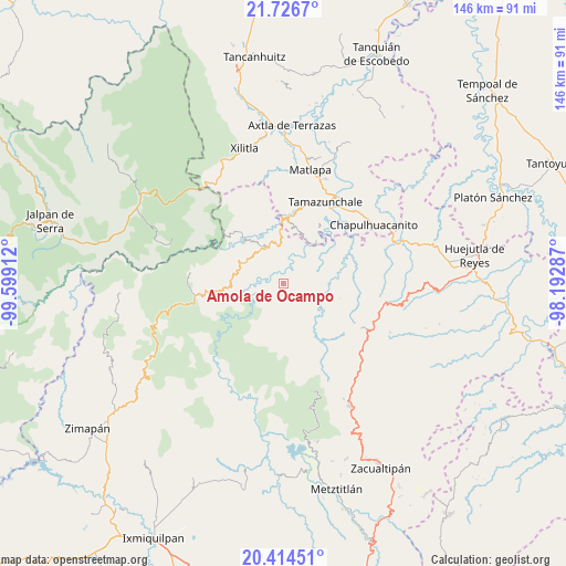
Amola de Ocampo GPS coordinates[2]
21° 4' 19.38" North, 98° 53' 45.564" West
| Map corner | latitude | longitude |
|---|---|---|
| Upper-left | 21.7267°, | -99.59912° |
| Center: | 21.07205°, | -98.89599° |
| Lower-right: | 20.41451°, | -98.19287° |
| Map W x H: | 145.9×145.9 km | = 90.7×90.7mi |
| max Lat: | 32.7° ⇑22.5% North |
| Amola de Ocampo: | 21.07205° |
| min Lat: | ⇓77.5% South 14.53588° |
| min Long | Amola de Ocampo | max Long |
| -117.105° | -98.89599° | -86.73105° |
| W 52.1%⇐ | ⇒47.9% E |
Elevation
Elevation of Amola de Ocampo is 1009 m = 3310 ft, and this is 244.7 m = 803 ft below average elevation for this country.
| Max E: |
3497 m = 11473 ft | 59.9% |
| Avg. | 1253.7 m = 4113 ft | |
| Amola de Ocampo | 1009 m = 3310 ft | |
Min E: |
-1 m = -3 ft | 40.1% |
See also: Mexico elevation on elevation.city.
Geographical zone
Amola de Ocampo is located in North Torrid zone (between Equator and Tropic of Cancer). Distance of this Northern Tropic circle is 262.9 km =163.4 mi to North.| Distance of | km | miles | from Amola de Ocampo |
|---|---|---|---|
| North Pole | 7664.1 | 4762.2 | to North |
| Arctic Circle | 5058.2 | 3143 | to North |
| Tropic Cancer | 262.9 | 163.4 | to North |
| Equator | 2343 | 1455.9 | to South |


Nearby cities:
15 places around Amola de Ocampo: (largest is in red/bold)
• Ahuatetla
3.8 km =2.4 mi,  210°
210°
• Cahuazas
8.7 km =5.4 mi,  29°
29°
• Chahuatitla
7.6 km =4.7 mi,  46°
46°
• Chilijapa
7.3 km =4.5 mi,  158°
158°
• Cuazahuatl
6.3 km =3.9 mi,  171°
171°
• Iglesia Vieja
8.3 km =5.2 mi,  297°
297°
• La Reforma
2.6 km =1.6 mi,  87°
87°
• Neblinas
5.6 km =3.5 mi,  329°
329°
• San Juan Ahuehueco
3.6 km =2.2 mi,  198°
198°
• San Rafael
6.5 km =4 mi,  318°
318°
• Tenango
4 km =2.5 mi,  245°
245°
• Tepehuacán de Guerrero
8.6 km =5.3 mi,  139°
139°
• Texcapa
4.9 km =3 mi,  62°
62°
• Teyahuala
5.8 km =3.6 mi,  114°
114°
• Xuchiatipa
8.2 km =5.1 mi,  224°
224°
Sources, notices
• [Note1] Compared only with cities in Mexico existing in our database
• [Src1] Map data: © OpenStreetMap contributors (CC-BY-SA)
• [Src2] Other city data from geonames.org with taken over terms of usage.
• [Src3] Geographical zone / Annual Mean Temperature by Robert A. Rohde @ Wikipedia
