La Reforma geodata
La Reforma (Hidalgo) is a populated place; located in Mexico in America/Mexico_City (GMT-6) time zone. With population of 1,212 people, there are 7183 cities with bigger population in this country. Compared to other cities in Mexico, 77.5% of cities are located further ↓South; 52.4% of cities are located further ←West and 70% of cities have higher elevation than La Reforma. Note1


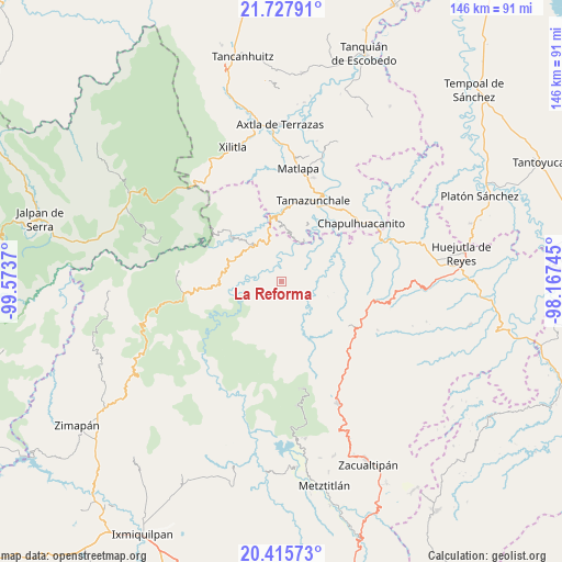
La Reforma GPS coordinates[2]
21° 4' 23.772" North, 98° 52' 14.052" West
| Map corner | latitude | longitude |
|---|---|---|
| Upper-left | 21.72791°, | -99.5737° |
| Center: | 21.07327°, | -98.87057° |
| Lower-right: | 20.41573°, | -98.16745° |
| Map W x H: | 145.9×145.9 km | = 90.7×90.7mi |
| max Lat: | 32.7° ⇑22.5% North |
| La Reforma: | 21.07327° |
| min Lat: | ⇓77.5% South 14.53588° |
| min Long | La Reforma | max Long |
| -117.105° | -98.87057° | -86.73105° |
| W 52.4%⇐ | ⇒47.6% E |
Elevation
Elevation of La Reforma is 416 m = 1365 ft, and this is 837.7 m = 2748 ft below average elevation for this country.
| Max E: |
3497 m = 11473 ft | 70% |
| Avg. | 1253.7 m = 4113 ft | |
| La Reforma | 416 m = 1365 ft | |
Min E: |
-1 m = -3 ft | 30% |
See also: Mexico elevation on elevation.city.
Geographical zone
La Reforma is located in North Torrid zone (between Equator and Tropic of Cancer). Distance of this Northern Tropic circle is 262.8 km =163.3 mi to North.| Distance of | km | miles | from La Reforma |
|---|---|---|---|
| North Pole | 7663.9 | 4762.1 | to North |
| Arctic Circle | 5058 | 3142.9 | to North |
| Tropic Cancer | 262.8 | 163.3 | to North |
| Equator | 2343.1 | 1455.9 | to South |


Nearby cities:
15 places around La Reforma: (largest is in red/bold)
• Ahuatetla
5.7 km =3.5 mi,  233°
233°
• Amola de Ocampo
2.6 km =1.6 mi,  267°
267°
• Cahuazas
7.7 km =4.8 mi,  12°
12°
• Chahuatitla
5.9 km =3.7 mi,  29°
29°
• Chilijapa
6.9 km =4.3 mi,  179°
179°
• Cuatolol
7 km =4.3 mi,  42°
42°
• Cuazahuatl
6.5 km =4 mi,  195°
195°
• Neblinas
7.2 km =4.5 mi,  310°
310°
• San Juan Ahuehueco
5.2 km =3.2 mi, 227°
• San Rafael
8.4 km =5.2 mi,  303°
303°
• Tenango
6.5 km =4 mi,  253°
253°
• Tepehuacán de Guerrero
7.3 km =4.5 mi,  155°
155°
• Texcapa
2.7 km =1.7 mi, 39°
• Teyahuala
3.7 km =2.3 mi,  134°
134°
• Xilitla
6.6 km =4.1 mi,  92°
92°
Sources, notices
• [Note1] Compared only with cities in Mexico existing in our database
• [Src1] Map data: © OpenStreetMap contributors (CC-BY-SA)
• [Src2] Other city data from geonames.org with taken over terms of usage.
• [Src3] Geographical zone / Annual Mean Temperature by Robert A. Rohde @ Wikipedia
