Chacama geodata
Chacama (Tabasco) is a populated place; located in Mexico in America/Mexico_City (GMT-6) time zone. With population of 505 people, there are 16660 cities with bigger population in this country. Compared to other cities in Mexico, 81.7% of cities are located further ↑North; 96.1% of cities are located further ←West and 85.5% of cities have higher elevation than Chacama. Note1


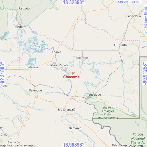
Chacama GPS coordinates[2]
17° 39' 36.72" North, 91° 36' 56.52" West
| Map corner | latitude | longitude |
|---|---|---|
| Upper-left | 18.32893°, | -92.31883° |
| Center: | 17.6602°, | -91.6157° |
| Lower-right: | 16.98898°, | -90.91258° |
| Map W x H: | 149×149 km | = 92.6×92.6mi |
| max Lat: | 32.7° ⇑81.7% North |
| Chacama: | 17.6602° |
| min Lat: | ⇓18.3% South 14.53588° |
| min Long | Chacama | max Long |
| -117.105° | -91.6157° | -86.73105° |
| W 96.1%⇐ | ⇒3.9% E |
Elevation
Elevation of Chacama is 41 m = 135 ft, and this is 1212.7 m = 3979 ft below average elevation for this country.
| Max E: |
3497 m = 11473 ft | 85.5% |
| Avg. | 1253.7 m = 4113 ft | |
| Chacama | 41 m = 135 ft | |
Min E: |
-1 m = -3 ft | 14.5% |
See also: Mexico elevation on elevation.city.
Geographical zone
Chacama is located in North Torrid zone (between Equator and Tropic of Cancer). Distance of this Northern Tropic circle is 642.3 km =399.1 mi to North.| Distance of | km | miles | from Chacama |
|---|---|---|---|
| North Pole | 8043.4 | 4997.9 | to North |
| Arctic Circle | 5437.5 | 3378.7 | to North |
| Tropic Cancer | 642.3 | 399.1 | to North |
| Equator | 1963.6 | 1220.1 | to South |


Nearby cities:
15 places around Chacama: (largest is in red/bold)
• Arena de Hidalgo
22.6 km =14 mi,  172°
172°
• Balancán
18.5 km =11.5 mi,  26°
26°
• Benito Juárez Centro
10.7 km =6.6 mi,  233°
233°
• Calatraba
22.6 km =14 mi,  306°
306°
• Emiliano Zapata
18.3 km =11.4 mi,  299°
299°
• Estapilla
25.7 km =16 mi,  119°
119°
• General Luis Felipe Domínguez Suárez
8.4 km =5.2 mi,  92°
92°
• José María Morelos y Pavón Centro
20.9 km =13 mi,  276°
276°
• La Isla
24.3 km =15.1 mi,  145°
145°
• La Libertad
11.5 km =7.1 mi,  285°
285°
• Leona Vicario
8.5 km =5.3 mi,  65°
65°
• Multé
25.2 km =15.7 mi,  82°
82°
• Netzahualcóyotl
19.1 km =11.9 mi, 72°
• Usumacinta
17.6 km =10.9 mi,  132°
132°
• Vicente Guerrero
12.1 km =7.5 mi,  349°
349°
Sources, notices
• [Note1] Compared only with cities in Mexico existing in our database
• [Src1] Map data: © OpenStreetMap contributors (CC-BY-SA)
• [Src2] Other city data from geonames.org with taken over terms of usage.
• [Src3] Geographical zone / Annual Mean Temperature by Robert A. Rohde @ Wikipedia
