Metlapa geodata
Metlapa (Guerrero) is a populated place; located in Mexico in America/Mexico_City (GMT-6) time zone. With population of 1,578 people, there are 5476 cities with bigger population in this country. Compared to other cities in Mexico, 74.8% of cities are located further ↑North; 58.7% of cities are located further →East and 64.8% of cities have higher elevation than Metlapa. Note1


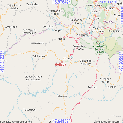
Metlapa GPS coordinates[2]
18° 18' 36.684" North, 99° 36' 32.76" West
| Map corner | latitude | longitude |
|---|---|---|
| Upper-left | 18.97642°, | -100.31223° |
| Center: | 18.31019°, | -99.6091° |
| Lower-right: | 17.64139°, | -98.90598° |
| Map W x H: | 148.4×148.4 km | = 92.2×92.2mi |
| max Lat: | 32.7° ⇑74.8% North |
| Metlapa: | 18.31019° |
| min Lat: | ⇓25.2% South 14.53588° |
| min Long | Metlapa | max Long |
| -117.105° | -99.6091° | -86.73105° |
| W 41.3%⇐ | ⇒58.7% E |
Elevation
Elevation of Metlapa is 700 m = 2297 ft, and this is 553.7 m = 1817 ft below average elevation for this country.
| Max E: |
3497 m = 11473 ft | 64.8% |
| Avg. | 1253.7 m = 4113 ft | |
| Metlapa | 700 m = 2297 ft | |
Min E: |
-1 m = -3 ft | 35.2% |
See also: Mexico elevation on elevation.city.
Geographical zone
Metlapa is located in North Torrid zone (between Equator and Tropic of Cancer). Distance of this Northern Tropic circle is 570 km =354.2 mi to North.| Distance of | km | miles | from Metlapa |
|---|---|---|---|
| North Pole | 7971.2 | 4953.1 | to North |
| Arctic Circle | 5365.3 | 3333.8 | to North |
| Tropic Cancer | 570 | 354.2 | to North |
| Equator | 2035.9 | 1265 | to South |


Nearby cities:
15 places around Metlapa: (largest is in red/bold)
• Ahuehuepan
5.5 km =3.4 mi,  307°
307°
• Apango
11.1 km =6.9 mi,  221°
221°
• Ceja Blanca
5.3 km =3.3 mi,  109°
109°
• Coatepec Costales
12.3 km =7.6 mi,  285°
285°
• Cocula
9.5 km =5.9 mi, 216°
• Colonia 15 de Septiembre
11.7 km =7.3 mi,  49°
49°
• Colonia Francisco Villa
12.1 km =7.5 mi, 49°
• Colonia Rancho del Cura (El Cura)
10.5 km =6.5 mi,  100°
100°
• El Naranjo
12.7 km =7.9 mi,  38°
38°
• Fermín Rabadán Cervantes
4.5 km =2.8 mi,  82°
82°
• Iguala de la Independencia
8.2 km =5.1 mi,  61°
61°
• Tepochica
9 km =5.6 mi, 95°
• Tlacuitlapa
10.6 km =6.6 mi,  281°
281°
• Tonalapa del Río
9.4 km =5.8 mi, 292°
• Zacacoyuca
10.9 km =6.8 mi,  127°
127°
Sources, notices
• [Note1] Compared only with cities in Mexico existing in our database
• [Src1] Map data: © OpenStreetMap contributors (CC-BY-SA)
• [Src2] Other city data from geonames.org with taken over terms of usage.
• [Src3] Geographical zone / Annual Mean Temperature by Robert A. Rohde @ Wikipedia
