Cocula geodata
Cocula (Guerrero) is a seat of a second-order administrative division; located in Mexico in America/Mexico_City (GMT-6) time zone. With population of 4,310 people, there are 2128 cities with bigger population in this country. Compared to other cities in Mexico, 75.7% of cities are located further ↑North; 59.7% of cities are located further →East and 66.4% of cities have higher elevation than Cocula. Note1


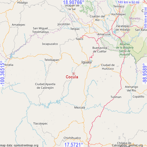
Cocula GPS coordinates[2]
18° 14' 28.176" North, 99° 39' 43.272" West
| Map corner | latitude | longitude |
|---|---|---|
| Upper-left | 18.90766°, | -100.36515° |
| Center: | 18.24116°, | -99.66202° |
| Lower-right: | 17.5721°, | -98.9589° |
| Map W x H: | 148.5×148.5 km | = 92.3×92.3mi |
| max Lat: | 32.7° ⇑75.7% North |
| Cocula: | 18.24116° |
| min Lat: | ⇓24.3% South 14.53588° |
| min Long | Cocula | max Long |
| -117.105° | -99.66202° | -86.73105° |
| W 40.3%⇐ | ⇒59.7% E |
Elevation
Elevation of Cocula is 616 m = 2021 ft, and this is 637.7 m = 2092 ft below average elevation for this country.
| Max E: |
3497 m = 11473 ft | 66.4% |
| Avg. | 1253.7 m = 4113 ft | |
| Cocula | 616 m = 2021 ft | |
Min E: |
-1 m = -3 ft | 33.6% |
See also: Mexico elevation on elevation.city.
Geographical zone
Cocula is located in North Torrid zone (between Equator and Tropic of Cancer). Distance of this Northern Tropic circle is 577.7 km =359 mi to North.| Distance of | km | miles | from Cocula |
|---|---|---|---|
| North Pole | 7978.8 | 4957.8 | to North |
| Arctic Circle | 5372.9 | 3338.6 | to North |
| Tropic Cancer | 577.7 | 359 | to North |
| Equator | 2028.2 | 1260.3 | to South |


Nearby cities:
15 places around Cocula: (largest is in red/bold)
• Ahuehuepan
11.1 km =6.9 mi,  6°
6°
• Apango
1.9 km =1.2 mi,  249°
249°
• Apetlanca
13.9 km =8.6 mi, 254°
• Apipilulco
5.7 km =3.5 mi,  190°
190°
• Atlixtac
4.6 km =2.9 mi,  196°
196°
• Ceja Blanca
12.1 km =7.5 mi,  60°
60°
• Chilacachapa
11.1 km =6.9 mi,  289°
289°
• Coatepec Costales
12.6 km =7.8 mi,  330°
330°
• Fermín Rabadán Cervantes
13 km =8.1 mi,  50°
50°
• Metlapa
9.5 km =5.9 mi,  36°
36°
• Sasamulco
13 km =8.1 mi,  135°
135°
• Tianquizolco
10 km =6.2 mi,  258°
258°
• Tlacuitlapa
10.8 km =6.7 mi, 333°
• Tlanipatlán
12.9 km =8 mi,  224°
224°
• Tonalapa del Río
11.6 km =7.2 mi,  344°
344°
Sources, notices
• [Note1] Compared only with cities in Mexico existing in our database
• [Src1] Map data: © OpenStreetMap contributors (CC-BY-SA)
• [Src2] Other city data from geonames.org with taken over terms of usage.
• [Src3] Geographical zone / Annual Mean Temperature by Robert A. Rohde @ Wikipedia
