Lototla geodata
Lototla (Hidalgo) is a populated place; located in Mexico in America/Mexico_City (GMT-6) time zone. With population of 703 people, there are 12379 cities with bigger population in this country. Compared to other cities in Mexico, 73.9% of cities are located further ↓South; 54.8% of cities are located further ←West and 55.6% of cities have lower elevation than Lototla. Note1


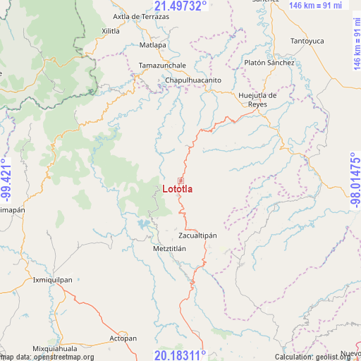
Lototla GPS coordinates[2]
20° 50' 29.94" North, 98° 43' 4.332" West
| Map corner | latitude | longitude |
|---|---|---|
| Upper-left | 21.49732°, | -99.421° |
| Center: | 20.84165°, | -98.71787° |
| Lower-right: | 20.18311°, | -98.01475° |
| Map W x H: | 146.1×146.1 km | = 90.8×90.8mi |
| max Lat: | 32.7° ⇑26.1% North |
| Lototla: | 20.84165° |
| min Lat: | ⇓73.9% South 14.53588° |
| min Long | Lototla | max Long |
| -117.105° | -98.71787° | -86.73105° |
| W 54.8%⇐ | ⇒45.2% E |
Elevation
Elevation of Lototla is 1604 m = 5262 ft, and this is 350.3 m = 1149 ft above average elevation for this country.
| Max E: |
3497 m = 11473 ft | 44.4% |
| Lototla | 1604 m 5262 ft | |
| Avg. | 1253.7 m = 4113 ft | |
Min E: |
-1 m = -3 ft | 55.6% |
See also: Mexico elevation on elevation.city.
Geographical zone
Lototla is located in North Torrid zone (between Equator and Tropic of Cancer). Distance of this Northern Tropic circle is 288.5 km =179.3 mi to North.| Distance of | km | miles | from Lototla |
|---|---|---|---|
| North Pole | 7689.7 | 4778.2 | to North |
| Arctic Circle | 5083.8 | 3158.9 | to North |
| Tropic Cancer | 288.5 | 179.3 | to North |
| Equator | 2317.4 | 1440 | to South |


Nearby cities:
15 places around Lototla: (largest is in red/bold)
• Acayuca
15.2 km =9.4 mi,  334°
334°
• Ahuacatlán
9.3 km =5.8 mi,  54°
54°
• Calnali
15.1 km =9.4 mi,  66°
66°
• Chipoco
14.9 km =9.3 mi,  5°
5°
• Eloxochitlán
14.5 km =9 mi,  220°
220°
• Ixtlahuaca
4.9 km =3 mi,  17°
17°
• Malila
12.3 km =7.6 mi,  181°
181°
• Molango
6.2 km =3.9 mi,  190°
190°
• Nonoalco
14.1 km =8.8 mi,  172°
172°
• San Antonio
13.3 km =8.3 mi,  294°
294°
• San Cristóbal
14 km =8.7 mi, 24°
• San Nicolás Cuatzontla
14.1 km =8.8 mi,  282°
282°
• Santa Mónica
14 km =8.7 mi,  156°
156°
• Texcaco
10.6 km =6.6 mi,  91°
91°
• Xochicoatlán
8.2 km =5.1 mi,  151°
151°
Sources, notices
• [Note1] Compared only with cities in Mexico existing in our database
• [Src1] Map data: © OpenStreetMap contributors (CC-BY-SA)
• [Src2] Other city data from geonames.org with taken over terms of usage.
• [Src3] Geographical zone / Annual Mean Temperature by Robert A. Rohde @ Wikipedia
