Texcaco geodata
Texcaco (Hidalgo) is a populated place; located in Mexico in America/Mexico_City (GMT-6) time zone. With population of 1,192 people, there are 7287 cities with bigger population in this country. Compared to other cities in Mexico, 73.9% of cities are located further ↓South; 55.9% of cities are located further ←West and 58.6% of cities have higher elevation than Texcaco. Note1


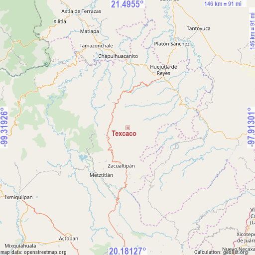
Texcaco GPS coordinates[2]
20° 50' 23.352" North, 98° 36' 58.068" West
| Map corner | latitude | longitude |
|---|---|---|
| Upper-left | 21.4955°, | -99.31926° |
| Center: | 20.83982°, | -98.61613° |
| Lower-right: | 20.18127°, | -97.91301° |
| Map W x H: | 146.1×146.1 km | = 90.8×90.8mi |
| max Lat: | 32.7° ⇑26.1% North |
| Texcaco: | 20.83982° |
| min Lat: | ⇓73.9% South 14.53588° |
| min Long | Texcaco | max Long |
| -117.105° | -98.61613° | -86.73105° |
| W 55.9%⇐ | ⇒44.1% E |
Elevation
Elevation of Texcaco is 1073 m = 3520 ft, and this is 180.7 m = 593 ft below average elevation for this country.
| Max E: |
3497 m = 11473 ft | 58.6% |
| Avg. | 1253.7 m = 4113 ft | |
| Texcaco | 1073 m = 3520 ft | |
Min E: |
-1 m = -3 ft | 41.4% |
See also: Mexico elevation on elevation.city.
Geographical zone
Texcaco is located in North Torrid zone (between Equator and Tropic of Cancer). Distance of this Northern Tropic circle is 288.7 km =179.4 mi to North.| Distance of | km | miles | from Texcaco |
|---|---|---|---|
| North Pole | 7689.9 | 4778.3 | to North |
| Arctic Circle | 5084 | 3159.1 | to North |
| Tropic Cancer | 288.7 | 179.4 | to North |
| Equator | 2317.2 | 1439.8 | to South |


Nearby cities:
15 places around Texcaco: (largest is in red/bold)
• Ahuacatlán
6.3 km =3.9 mi,  331°
331°
• Calnali
7.1 km =4.4 mi,  26°
26°
• Chichatla
13.2 km =8.2 mi,  354°
354°
• Ixcotitlán
12.9 km =8 mi,  136°
136°
• Ixtlahuaca
10.3 km =6.4 mi,  298°
298°
• Lototla
10.6 km =6.6 mi,  271°
271°
• Molango
13.1 km =8.1 mi,  243°
243°
• San Andrés (San Andrés Chichayotla)
11.1 km =6.9 mi, 29°
• San Miguel
7.5 km =4.7 mi,  105°
105°
• Tecpaco
10.4 km =6.5 mi,  14°
14°
• Tianguistengo
12.5 km =7.8 mi,  187°
187°
• Tuzancoac
6.6 km =4.1 mi,  75°
75°
• Xochicoatlán
9.7 km =6 mi,  223°
223°
• Xochimilco
12.3 km =7.6 mi,  118°
118°
• Zacatipán
10.9 km =6.8 mi,  91°
91°
Sources, notices
• [Note1] Compared only with cities in Mexico existing in our database
• [Src1] Map data: © OpenStreetMap contributors (CC-BY-SA)
• [Src2] Other city data from geonames.org with taken over terms of usage.
• [Src3] Geographical zone / Annual Mean Temperature by Robert A. Rohde @ Wikipedia
