Ixtlahuaca geodata
Ixtlahuaca (Hidalgo) is a populated place; located in Mexico in America/Mexico_City (GMT-6) time zone. With population of 1,222 people, there are 7104 cities with bigger population in this country. Compared to other cities in Mexico, 74.6% of cities are located further ↓South; 55.1% of cities are located further ←West and 50.1% of cities have higher elevation than Ixtlahuaca. Note1


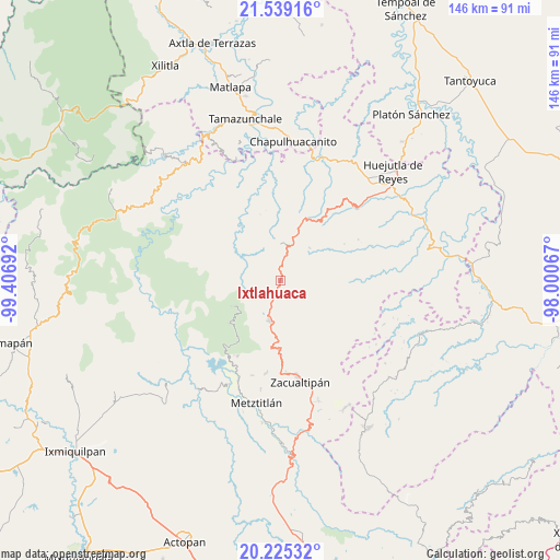
Ixtlahuaca GPS coordinates[2]
20° 53' 1.248" North, 98° 42' 13.644" West
| Map corner | latitude | longitude |
|---|---|---|
| Upper-left | 21.53916°, | -99.40692° |
| Center: | 20.88368°, | -98.70379° |
| Lower-right: | 20.22532°, | -98.00067° |
| Map W x H: | 146.1×146.1 km | = 90.8×90.8mi |
| max Lat: | 32.7° ⇑25.4% North |
| Ixtlahuaca: | 20.88368° |
| min Lat: | ⇓74.6% South 14.53588° |
| min Long | Ixtlahuaca | max Long |
| -117.105° | -98.70379° | -86.73105° |
| W 55.1%⇐ | ⇒44.9% E |
Elevation
Elevation of Ixtlahuaca is 1426 m = 4678 ft, and this is 172.3 m = 565 ft above average elevation for this country.
| Max E: |
3497 m = 11473 ft | 50.1% |
| Ixtlahuaca | 1426 m 4678 ft | |
| Avg. | 1253.7 m = 4113 ft | |
Min E: |
-1 m = -3 ft | 49.9% |
See also: Mexico elevation on elevation.city.
Geographical zone
Ixtlahuaca is located in North Torrid zone (between Equator and Tropic of Cancer). Distance of this Northern Tropic circle is 283.9 km =176.4 mi to North.| Distance of | km | miles | from Ixtlahuaca |
|---|---|---|---|
| North Pole | 7685 | 4775.2 | to North |
| Arctic Circle | 5079.1 | 3156 | to North |
| Tropic Cancer | 283.9 | 176.4 | to North |
| Equator | 2322 | 1442.8 | to South |


Nearby cities:
15 places around Ixtlahuaca: (largest is in red/bold)
• Acayuca
12.1 km =7.5 mi,  318°
318°
• Acoxcatlán
12.6 km =7.8 mi, 322°
• Ahuacatlán
6.1 km =3.8 mi,  83°
83°
• Calnali
12.4 km =7.7 mi, 83°
• Chichatla
11.3 km =7 mi,  42°
42°
• Chipoco
10.2 km =6.3 mi,  0°
0°
• Lototla
4.9 km =3 mi,  197°
197°
• Molango
11.1 km =6.9 mi,  193°
193°
• San Antonio
13.6 km =8.5 mi,  273°
273°
• San Cristóbal
9.1 km =5.7 mi,  28°
28°
• Tecpaco
12.8 km =8 mi,  66°
66°
• Texcaco
10.3 km =6.4 mi,  118°
118°
• Tlanchinol
13 km =8.1 mi,  21°
21°
• Tolago
10.8 km =6.7 mi,  346°
346°
• Xochicoatlán
12.1 km =7.5 mi,  168°
168°
Sources, notices
• [Note1] Compared only with cities in Mexico existing in our database
• [Src1] Map data: © OpenStreetMap contributors (CC-BY-SA)
• [Src2] Other city data from geonames.org with taken over terms of usage.
• [Src3] Geographical zone / Annual Mean Temperature by Robert A. Rohde @ Wikipedia
