Almoloya geodata
Almoloya (Hidalgo) is a seat of a second-order administrative division; located in Mexico in America/Mexico_City (GMT-6) time zone. With population of 4,802 people, there are 1927 cities with bigger population in this country. Compared to other cities in Mexico, 50.6% of cities are located further ↓South; 58.5% of cities are located further ←West and 93.1% of cities have lower elevation than Almoloya. Note1


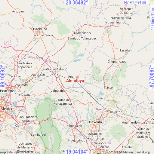
Almoloya GPS coordinates[2]
19° 42' 15.66" North, 98° 24' 13.644" West
| Map corner | latitude | longitude |
|---|---|---|
| Upper-left | 20.36492°, | -99.10692° |
| Center: | 19.70435°, | -98.40379° |
| Lower-right: | 19.04104°, | -97.70067° |
| Map W x H: | 147.2×147.2 km | = 91.5×91.5mi |
| max Lat: | 32.7° ⇑49.4% North |
| Almoloya: | 19.70435° |
| min Lat: | ⇓50.6% South 14.53588° |
| min Long | Almoloya | max Long |
| -117.105° | -98.40379° | -86.73105° |
| W 58.5%⇐ | ⇒41.5% E |
Elevation
Elevation of Almoloya is 2536 m = 8320 ft, and this is 1282.3 m = 4207 ft above average elevation for this country.
| Max E: |
3497 m = 11473 ft | 6.9% |
| Almoloya | 2536 m 8320 ft | |
| Avg. | 1253.7 m = 4113 ft | |
Min E: |
-1 m = -3 ft | 93.1% |
See also: Mexico elevation on elevation.city.
Geographical zone
Almoloya is located in North Torrid zone (between Equator and Tropic of Cancer). Distance of this Northern Tropic circle is 415 km =257.9 mi to North.| Distance of | km | miles | from Almoloya |
|---|---|---|---|
| North Pole | 7816.1 | 4856.7 | to North |
| Arctic Circle | 5210.3 | 3237.5 | to North |
| Tropic Cancer | 415 | 257.9 | to North |
| Equator | 2190.9 | 1361.4 | to South |


Nearby cities:
15 places around Almoloya: (largest is in red/bold)
• Apan
5 km =3.1 mi,  278°
278°
• Benito Juárez
13.4 km =8.3 mi,  191°
191°
• Chimalpa y Tlalayote
12.2 km =7.6 mi,  249°
249°
• Colonia 20 de Noviembre
12.9 km =8 mi,  303°
303°
• Jiquilpan
8.7 km =5.4 mi,  169°
169°
• La Laguna
10.6 km =6.6 mi,  288°
288°
• Lomas del Pedregal
10.3 km =6.4 mi, 296°
• Los Voladores
9.8 km =6.1 mi,  255°
255°
• Lázaro Cárdenas
10.1 km =6.3 mi,  224°
224°
• Ocotepec
3.2 km =2 mi, 253°
• Ocotepec de Morelos
4.3 km =2.7 mi,  144°
144°
• San Juan Ixtilmaco
6.4 km =4 mi,  228°
228°
• Santiago Tetlapayac
7.6 km =4.7 mi,  101°
101°
• Tepepatlaxco
6.3 km =3.9 mi,  32°
32°
• Unión Ejidal Tierra y Libertad
8.7 km =5.4 mi,  126°
126°
Sources, notices
• [Note1] Compared only with cities in Mexico existing in our database
• [Src1] Map data: © OpenStreetMap contributors (CC-BY-SA)
• [Src2] Other city data from geonames.org with taken over terms of usage.
• [Src3] Geographical zone / Annual Mean Temperature by Robert A. Rohde @ Wikipedia
