La Vigueta geodata
La Vigueta (Veracruz) is a populated place; located in Mexico in America/Mexico_City (GMT-6) time zone. With population of 614 people, there are 14035 cities with bigger population in this country. Compared to other cities in Mexico, 64.2% of cities are located further ↓South; 76.3% of cities are located further ←West and 95.7% of cities have higher elevation than La Vigueta. Note1


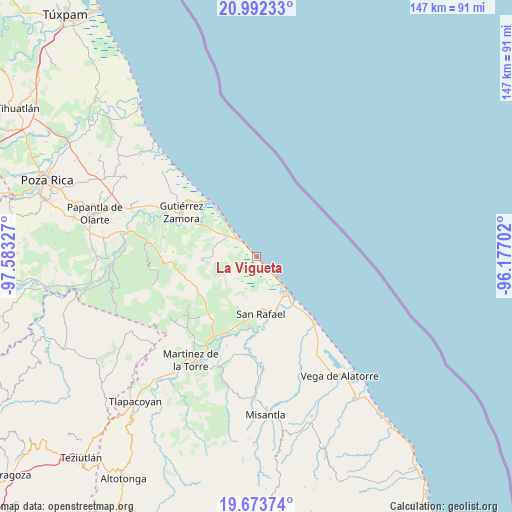
La Vigueta GPS coordinates[2]
20° 20' 3.984" North, 96° 52' 48.504" West
| Map corner | latitude | longitude |
|---|---|---|
| Upper-left | 20.99233°, | -97.58327° |
| Center: | 20.33444°, | -96.88014° |
| Lower-right: | 19.67374°, | -96.17702° |
| Map W x H: | 146.6×146.6 km | = 91.1×91.1mi |
| max Lat: | 32.7° ⇑35.8% North |
| La Vigueta: | 20.33444° |
| min Lat: | ⇓64.2% South 14.53588° |
| min Long | La Vigueta | max Long |
| -117.105° | -96.88014° | -86.73105° |
| W 76.3%⇐ | ⇒23.7% E |
Elevation
Elevation of La Vigueta is 12 m = 39 ft, and this is 1241.7 m = 4074 ft below average elevation for this country.
| Max E: |
3497 m = 11473 ft | 95.7% |
| Avg. | 1253.7 m = 4113 ft | |
| La Vigueta | 12 m = 39 ft | |
Min E: |
-1 m = -3 ft | 4.3% |
See also: Mexico elevation on elevation.city.
Geographical zone
La Vigueta is located in North Torrid zone (between Equator and Tropic of Cancer). Distance of this Northern Tropic circle is 344.9 km =214.3 mi to North.| Distance of | km | miles | from La Vigueta |
|---|---|---|---|
| North Pole | 7746.1 | 4813.2 | to North |
| Arctic Circle | 5140.2 | 3194 | to North |
| Tropic Cancer | 344.9 | 214.3 | to North |
| Equator | 2261 | 1404.9 | to South |


Nearby cities:
15 places around La Vigueta: (largest is in red/bold)
• Casitas
12.1 km =7.5 mi,  136°
136°
• Cementeras del Pital
17.6 km =10.9 mi,  185°
185°
• Ejido Vega de San Marcos
16.1 km =10 mi,  202°
202°
• El Cabellal
15 km =9.3 mi,  230°
230°
• El Guayabal
18.1 km =11.2 mi,  178°
178°
• Emiliano Zapata
13.4 km =8.3 mi,  218°
218°
• Fuerte de Anaya
10 km =6.2 mi,  245°
245°
• Hueytepec
15.3 km =9.5 mi,  266°
266°
• La Guadalupe
5.9 km =3.7 mi,  316°
316°
• Melchor Ocampo
16.2 km =10.1 mi,  158°
158°
• Monte Gordo
6.5 km =4 mi, 137°
• Nautla
18 km =11.2 mi, 141°
• Puntilla Aldama
16.4 km =10.2 mi, 189°
• Ricardo Flores Magón
3.7 km =2.3 mi, 316°
• San Rafael
16.3 km =10.1 mi, 175°
Sources, notices
• [Note1] Compared only with cities in Mexico existing in our database
• [Src1] Map data: © OpenStreetMap contributors (CC-BY-SA)
• [Src2] Other city data from geonames.org with taken over terms of usage.
• [Src3] Geographical zone / Annual Mean Temperature by Robert A. Rohde @ Wikipedia
