La Venta geodata
La Venta (Oaxaca) is a populated place; located in Mexico in America/Mexico_City (GMT-6) time zone. With population of 2,161 people, there are 4067 cities with bigger population in this country. Compared to other cities in Mexico, 93.8% of cities are located further ↑North; 85% of cities are located further ←West and 87.5% of cities have higher elevation than La Venta. Note1


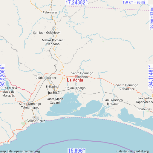
La Venta GPS coordinates[2]
16° 34' 15.924" North, 94° 49' 3.828" West
| Map corner | latitude | longitude |
|---|---|---|
| Upper-left | 17.24382°, | -95.52086° |
| Center: | 16.57109°, | -94.81773° |
| Lower-right: | 15.896°, | -94.11461° |
| Map W x H: | 149.9×149.9 km | = 93.1×93.1mi |
| max Lat: | 32.7° ⇑93.8% North |
| La Venta: | 16.57109° |
| min Lat: | ⇓6.2% South 14.53588° |
| min Long | La Venta | max Long |
| -117.105° | -94.81773° | -86.73105° |
| W 85%⇐ | ⇒15% E |
Elevation
Elevation of La Venta is 32 m = 105 ft, and this is 1221.7 m = 4008 ft below average elevation for this country.
| Max E: |
3497 m = 11473 ft | 87.5% |
| Avg. | 1253.7 m = 4113 ft | |
| La Venta | 32 m = 105 ft | |
Min E: |
-1 m = -3 ft | 12.5% |
See also: Mexico elevation on elevation.city.
Geographical zone
La Venta is located in North Torrid zone (between Equator and Tropic of Cancer). Distance of this Northern Tropic circle is 763.4 km =474.4 mi to North.| Distance of | km | miles | from La Venta |
|---|---|---|---|
| North Pole | 8164.5 | 5073.2 | to North |
| Arctic Circle | 5558.6 | 3454 | to North |
| Tropic Cancer | 763.4 | 474.4 | to North |
| Equator | 1842.5 | 1144.9 | to South |


Nearby cities:
15 places around La Venta: (largest is in red/bold)
• Asunción Ixtaltepec
27 km =16.8 mi,  253°
253°
• Chicapa de Castro
14.8 km =9.2 mi,  181°
181°
• Chivela
24.8 km =15.4 mi,  309°
309°
• El Espinal
25.5 km =15.8 mi, 248°
• El Porvenir
9.4 km =5.8 mi,  21°
21°
• Guamúchil
27.5 km =17.1 mi,  144°
144°
• Juchitán de Zaragoza
26.3 km =16.3 mi,  235°
235°
• La Blanca
13.6 km =8.5 mi,  78°
78°
• La Ventosa
14 km =8.7 mi,  261°
261°
• Las Conchas
14.9 km =9.3 mi,  46°
46°
• Lázaro Cárdenas
18 km =11.2 mi,  345°
345°
• Niltepec
21.8 km =13.5 mi,  92°
92°
• San Miguel Chimalapa
17.6 km =10.9 mi, 24°
• Santiago Ixtaltepec
16.1 km =10 mi,  324°
324°
• Unión Hidalgo
11.1 km =6.9 mi,  186°
186°
Sources, notices
• [Note1] Compared only with cities in Mexico existing in our database
• [Src1] Map data: © OpenStreetMap contributors (CC-BY-SA)
• [Src2] Other city data from geonames.org with taken over terms of usage.
• [Src3] Geographical zone / Annual Mean Temperature by Robert A. Rohde @ Wikipedia
