San Miguel Chimalapa geodata
San Miguel Chimalapa (Oaxaca) is a populated place; located in Mexico in America/Mexico_City (GMT-6) time zone. With population of 1,444 people, there are 5977 cities with bigger population in this country. Compared to other cities in Mexico, 92.7% of cities are located further ↑North; 85.1% of cities are located further ←West and 78.1% of cities have higher elevation than San Miguel Chimalapa. Note1
Current local time in San Miguel Chimalapa:
05:23 AM, WednesdayDifference from your time zone: hours


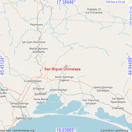
San Miguel Chimalapa GPS coordinates[2]
16° 42' 51.264" North, 94° 44' 53.196" West
| Map corner | latitude | longitude |
|---|---|---|
| Upper-left | 17.38646°, | -95.45124° |
| Center: | 16.71424°, | -94.74811° |
| Lower-right: | 16.03965°, | -94.04499° |
| Map W x H: | 149.8×149.8 km | = 93.1×93.1mi |
| max Lat: | 32.7° ⇑92.7% North |
| San Miguel Chimalapa: | 16.71424° |
| min Lat: | ⇓7.3% South 14.53588° |
| min Long | San Miguel Chim | max Long |
| -117.105° | -94.74811° | -86.73105° |
| W 85.1%⇐ | ⇒14.9% E |
Elevation
Elevation of San Miguel Chimalapa is 128 m = 420 ft, and this is 1125.7 m = 3693 ft below average elevation for this country.
| Max E: |
3497 m = 11473 ft | 78.1% |
| Avg. | 1253.7 m = 4113 ft | |
| San Miguel Chimalapa | 128 m = 420 ft | |
Min E: |
-1 m = -3 ft | 21.9% |
See also: Mexico elevation on elevation.city.
Geographical zone
San Miguel Chimalapa is located in North Torrid zone (between Equator and Tropic of Cancer). Distance of this Northern Tropic circle is 747.5 km =464.5 mi to North.| Distance of | km | miles | from San Miguel Chimalapa |
|---|---|---|---|
| North Pole | 8148.6 | 5063.3 | to North |
| Arctic Circle | 5542.7 | 3444.1 | to North |
| Tropic Cancer | 747.5 | 464.5 | to North |
| Equator | 1858.4 | 1154.8 | to South |


Nearby cities:
15 places around San Miguel Chimalapa: (largest is in red/bold)
• Barreña
33.7 km =20.9 mi,  317°
317°
• Chicapa de Castro
31.7 km =19.7 mi,  194°
194°
• Chivela
26.5 km =16.5 mi,  269°
269°
• Chivixhuyo
25.4 km =15.8 mi,  295°
295°
• El Porvenir
8.2 km =5.1 mi,  208°
208°
• La Blanca
14.5 km =9 mi,  155°
155°
• La Venta
17.6 km =10.9 mi,  204°
204°
• La Ventosa
27.9 km =17.3 mi,  229°
229°
• Las Conchas
6.7 km =4.2 mi,  148°
148°
• Lázaro Cárdenas
12 km =7.5 mi,  277°
277°
• Niltepec
22 km =13.7 mi,  139°
139°
• Niza Conejo
35.5 km =22.1 mi,  287°
287°
• Santa María Chimalapa
22.5 km =14 mi,  17°
17°
• Santiago Ixtaltepec
17 km =10.6 mi,  260°
260°
• Unión Hidalgo
28.3 km =17.6 mi, 197°
Sources, notices
• [Note1] Compared only with cities in Mexico existing in our database
• [Src1] Map data: © OpenStreetMap contributors (CC-BY-SA)
• [Src2] Other city data from geonames.org with taken over terms of usage.
• [Src3] Geographical zone / Annual Mean Temperature by Robert A. Rohde @ Wikipedia
