Cuarto Cantón geodata
Cuarto Cantón (Chiapas) is a populated place; located in Mexico in America/Mexico_City (GMT-6) time zone. With population of 911 people, there are 9575 cities with bigger population in this country. Compared to other cities in Mexico, 99.2% of cities are located further ↑North; 92.4% of cities are located further ←West and 88% of cities have higher elevation than Cuarto Cantón. Note1


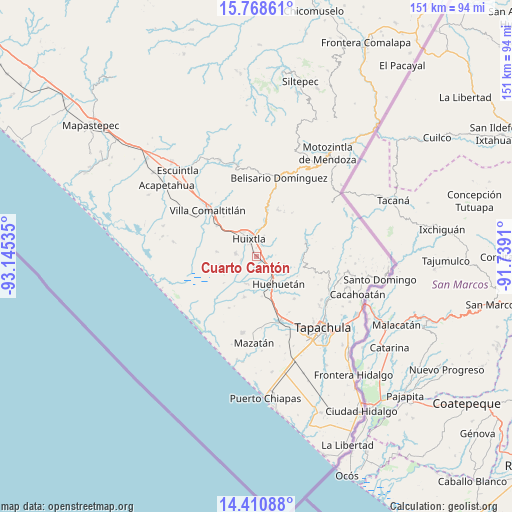
Cuarto Cantón GPS coordinates[2]
15° 5' 26.988" North, 92° 26' 31.992" West
| Map corner | latitude | longitude |
|---|---|---|
| Upper-left | 15.76861°, | -93.14535° |
| Center: | 15.09083°, | -92.44222° |
| Lower-right: | 14.41088°, | -91.7391° |
| Map W x H: | 151×151 km | = 93.8×93.8mi |
| max Lat: | 32.7° ⇑99.2% North |
| Cuarto Cantón: | 15.09083° |
| min Lat: | ⇓0.8% South 14.53588° |
| min Long | Cuarto Cantón | max Long |
| -117.105° | -92.44222° | -86.73105° |
| W 92.4%⇐ | ⇒7.6% E |
Elevation
Elevation of Cuarto Cantón is 30 m = 98 ft, and this is 1223.7 m = 4015 ft below average elevation for this country.
| Max E: |
3497 m = 11473 ft | 88% |
| Avg. | 1253.7 m = 4113 ft | |
| Cuarto Cantón | 30 m = 98 ft | |
Min E: |
-1 m = -3 ft | 12% |
See also: Mexico elevation on elevation.city.
Geographical zone
Cuarto Cantón is located in North Torrid zone (between Equator and Tropic of Cancer). Distance of this Northern Tropic circle is 928 km =576.6 mi to North.| Distance of | km | miles | from Cuarto Cantón |
|---|---|---|---|
| North Pole | 8329.1 | 5175.5 | to North |
| Arctic Circle | 5723.2 | 3556.2 | to North |
| Tropic Cancer | 928 | 576.6 | to North |
| Equator | 1677.9 | 1042.6 | to South |


Nearby cities:
15 places around Cuarto Cantón: (largest is in red/bold)
• Cantón la Lima
7.3 km =4.5 mi,  173°
173°
• Cantón las Delicias
6.3 km =3.9 mi,  281°
281°
• Chamulapa
5.8 km =3.6 mi,  135°
135°
• Colonia Obrera
6 km =3.7 mi, 277°
• Cuyamiapa
6.5 km =4 mi,  157°
157°
• El Arenal
4.8 km =3 mi,  260°
260°
• El Chipilín
3.7 km =2.3 mi,  26°
26°
• Estación Tuzantán
2 km =1.2 mi,  331°
331°
• Huixtla
5.9 km =3.7 mi,  336°
336°
• La Flor
6.3 km =3.9 mi,  0°
0°
• Primer Cantón
3.3 km =2.1 mi, 4°
• Segundo Cantón
1.3 km =0.8 mi, 34°
• Tuzantán
6.6 km =4.1 mi,  18°
18°
• Veintinueve de Diciembre
6 km =3.7 mi,  350°
350°
• Xochiltepec
4.2 km =2.6 mi,  12°
12°
Sources, notices
• [Note1] Compared only with cities in Mexico existing in our database
• [Src1] Map data: © OpenStreetMap contributors (CC-BY-SA)
• [Src2] Other city data from geonames.org with taken over terms of usage.
• [Src3] Geographical zone / Annual Mean Temperature by Robert A. Rohde @ Wikipedia
