San José el Amate geodata
San José el Amate (Chiapas) is a populated place; located in Mexico in America/Mexico_City (GMT-6) time zone. With population of 947 people, there are 9196 cities with bigger population in this country. Compared to other cities in Mexico, 99.5% of cities are located further ↑North; 92.4% of cities are located further ←West and 90.8% of cities have higher elevation than San José el Amate. Note1


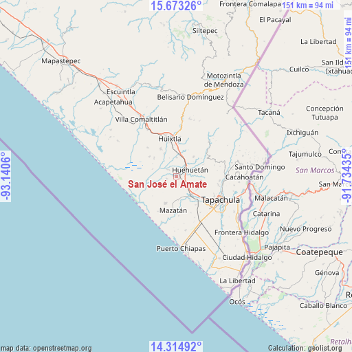
San José el Amate GPS coordinates[2]
14° 59' 42.612" North, 92° 26' 14.892" West
| Map corner | latitude | longitude |
|---|---|---|
| Upper-left | 15.67326°, | -93.1406° |
| Center: | 14.99517°, | -92.43747° |
| Lower-right: | 14.31492°, | -91.73435° |
| Map W x H: | 151×151 km | = 93.8×93.8mi |
| max Lat: | 32.7° ⇑99.5% North |
| San José el Amate: | 14.99517° |
| min Lat: | ⇓0.5% South 14.53588° |
| min Long | San José el Am | max Long |
| -117.105° | -92.43747° | -86.73105° |
| W 92.4%⇐ | ⇒7.6% E |
Elevation
Elevation of San José el Amate is 22 m = 72 ft, and this is 1231.7 m = 4041 ft below average elevation for this country.
| Max E: |
3497 m = 11473 ft | 90.8% |
| Avg. | 1253.7 m = 4113 ft | |
| San José el Amate | 22 m = 72 ft | |
Min E: |
-1 m = -3 ft | 9.2% |
See also: Mexico elevation on elevation.city.
Geographical zone
San José el Amate is located in North Torrid zone (between Equator and Tropic of Cancer). Distance of this Northern Tropic circle is 938.6 km =583.2 mi to North.| Distance of | km | miles | from San José el Amate |
|---|---|---|---|
| North Pole | 8339.8 | 5182.1 | to North |
| Arctic Circle | 5733.9 | 3562.9 | to North |
| Tropic Cancer | 938.6 | 583.2 | to North |
| Equator | 1667.3 | 1036 | to South |


Nearby cities:
15 places around San José el Amate: (largest is in red/bold)
• Aquiles Serdán
10.3 km =6.4 mi,  233°
233°
• Cantón la Lima
3.4 km =2.1 mi,  5°
5°
• Chamulapa
7.4 km =4.6 mi,  28°
28°
• Cuarto Cantón
10.6 km =6.6 mi,  357°
357°
• Cuntalapa
5.6 km =3.5 mi,  50°
50°
• Cuyamiapa
5.1 km =3.2 mi,  23°
23°
• Estación Huehuetán
3.7 km =2.3 mi,  62°
62°
• Guachipilín
1.4 km =0.9 mi,  151°
151°
• Huehuetán
6.5 km =4 mi,  65°
65°
• La Unión
10.3 km =6.4 mi,  310°
310°
• Marte R. Gómez
7.7 km =4.8 mi,  185°
185°
• Nueva Victoria
4.7 km =2.9 mi, 305°
• Plan de Ayala
4.4 km =2.7 mi,  253°
253°
• Plan de Iguala
8.1 km =5 mi,  241°
241°
• Álvaro Obregón
10.3 km =6.4 mi,  141°
141°
Sources, notices
• [Note1] Compared only with cities in Mexico existing in our database
• [Src1] Map data: © OpenStreetMap contributors (CC-BY-SA)
• [Src2] Other city data from geonames.org with taken over terms of usage.
• [Src3] Geographical zone / Annual Mean Temperature by Robert A. Rohde @ Wikipedia
