Segundo Cantón geodata
Segundo Cantón (Chiapas) is a populated place; located in Mexico in America/Mexico_City (GMT-6) time zone. With population of 952 people, there are 9147 cities with bigger population in this country. Compared to other cities in Mexico, 99.2% of cities are located further ↑North; 92.4% of cities are located further ←West and 86.5% of cities have higher elevation than Segundo Cantón. Note1


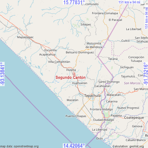
Segundo Cantón GPS coordinates[2]
15° 6' 2.016" North, 92° 26' 7.008" West
| Map corner | latitude | longitude |
|---|---|---|
| Upper-left | 15.77831°, | -93.13841° |
| Center: | 15.10056°, | -92.43528° |
| Lower-right: | 14.42064°, | -91.73216° |
| Map W x H: | 151×151 km | = 93.8×93.8mi |
| max Lat: | 32.7° ⇑99.2% North |
| Segundo Cantón: | 15.10056° |
| min Lat: | ⇓0.8% South 14.53588° |
| min Long | Segundo Cantón | max Long |
| -117.105° | -92.43528° | -86.73105° |
| W 92.4%⇐ | ⇒7.6% E |
Elevation
Elevation of Segundo Cantón is 36 m = 118 ft, and this is 1217.7 m = 3995 ft below average elevation for this country.
| Max E: |
3497 m = 11473 ft | 86.5% |
| Avg. | 1253.7 m = 4113 ft | |
| Segundo Cantón | 36 m = 118 ft | |
Min E: |
-1 m = -3 ft | 13.5% |
See also: Mexico elevation on elevation.city.
Geographical zone
Segundo Cantón is located in North Torrid zone (between Equator and Tropic of Cancer). Distance of this Northern Tropic circle is 926.9 km =575.9 mi to North.| Distance of | km | miles | from Segundo Cantón |
|---|---|---|---|
| North Pole | 8328 | 5174.8 | to North |
| Arctic Circle | 5722.1 | 3555.5 | to North |
| Tropic Cancer | 926.9 | 575.9 | to North |
| Equator | 1679 | 1043.3 | to South |


Nearby cities:
15 places around Segundo Cantón: (largest is in red/bold)
• Cantón las Delicias
7 km =4.3 mi,  271°
271°
• Chamulapa
6.2 km =3.9 mi,  147°
147°
• Colonia Obrera
6.7 km =4.2 mi, 267°
• Cuarto Cantón
1.3 km =0.8 mi,  214°
214°
• Cuyamiapa
7.3 km =4.5 mi,  165°
165°
• El Arenal
5.8 km =3.6 mi,  250°
250°
• El Chipilín
2.4 km =1.5 mi,  21°
21°
• Estación Tuzantán
1.8 km =1.1 mi,  291°
291°
• Huixtla
5.3 km =3.3 mi,  324°
324°
• La Flor
5.2 km =3.2 mi,  351°
351°
• Primer Cantón
2.3 km =1.4 mi, 347°
• Tuzantán
5.4 km =3.4 mi,  14°
14°
• Veintinueve de Diciembre
5.1 km =3.2 mi,  340°
340°
• Villa Hidalgo
6.6 km =4.1 mi,  84°
84°
• Xochiltepec
3 km =1.9 mi,  2°
2°
Sources, notices
• [Note1] Compared only with cities in Mexico existing in our database
• [Src1] Map data: © OpenStreetMap contributors (CC-BY-SA)
• [Src2] Other city data from geonames.org with taken over terms of usage.
• [Src3] Geographical zone / Annual Mean Temperature by Robert A. Rohde @ Wikipedia
