Jalpan geodata
Jalpan (Querétaro) is a seat of a second-order administrative division; located in Mexico in America/Mexico_City (GMT-6) time zone. With population of 11,010 people, there are 862 cities with bigger population in this country. Compared to other cities in Mexico, 79.3% of cities are located further ↓South; 56.6% of cities are located further →East and 64.1% of cities have higher elevation than Jalpan. Note1


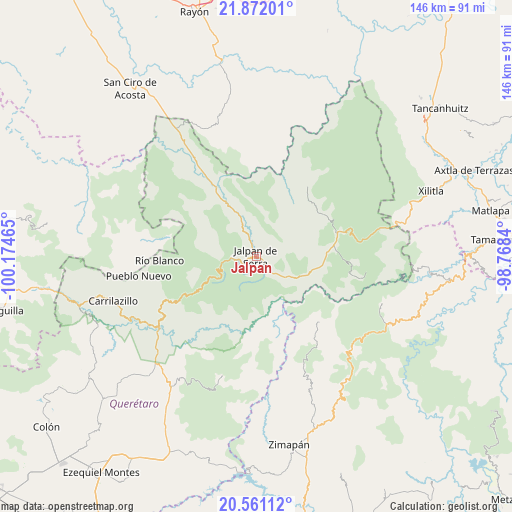
Jalpan GPS coordinates[2]
21° 13' 4.872" North, 99° 28' 17.472" West
| Map corner | latitude | longitude |
|---|---|---|
| Upper-left | 21.87201°, | -100.17465° |
| Center: | 21.21802°, | -99.47152° |
| Lower-right: | 20.56112°, | -98.7684° |
| Map W x H: | 145.8×145.8 km | = 90.6×90.6mi |
| max Lat: | 32.7° ⇑20.7% North |
| Jalpan: | 21.21802° |
| min Lat: | ⇓79.3% South 14.53588° |
| min Long | Jalpan | max Long |
| -117.105° | -99.47152° | -86.73105° |
| W 43.4%⇐ | ⇒56.6% E |
Elevation
Elevation of Jalpan is 744 m = 2441 ft, and this is 509.7 m = 1672 ft below average elevation for this country.
| Max E: |
3497 m = 11473 ft | 64.1% |
| Avg. | 1253.7 m = 4113 ft | |
| Jalpan | 744 m = 2441 ft | |
Min E: |
-1 m = -3 ft | 35.9% |
See also: Mexico elevation on elevation.city.
Geographical zone
Jalpan is located in North Torrid zone (between Equator and Tropic of Cancer). Distance of this Northern Tropic circle is 246.7 km =153.3 mi to North.| Distance of | km | miles | from Jalpan |
|---|---|---|---|
| North Pole | 7647.8 | 4752.1 | to North |
| Arctic Circle | 5042 | 3133 | to North |
| Tropic Cancer | 246.7 | 153.3 | to North |
| Equator | 2359.2 | 1465.9 | to South |


Nearby cities:
15 places around Jalpan: (largest is in red/bold)
• Ahuacatlán de Guadalupe
7.2 km =4.5 mi,  267°
267°
• Atarjea
26.3 km =16.3 mi,  282°
282°
• El Lindero
7.4 km =4.6 mi,  335°
335°
• Encino Solo
21.7 km =13.5 mi,  79°
79°
• La Lagunita
22.2 km =13.8 mi, 81°
• La Vuelta
25.1 km =15.6 mi,  72°
72°
• Landa de Matamoros
16.1 km =10 mi,  103°
103°
• Otates
27.7 km =17.2 mi,  106°
106°
• Pacula
26 km =16.2 mi,  135°
135°
• Pinal de Amoles
18.5 km =11.5 mi,  239°
239°
• Purísima de Arista
11.2 km =7 mi, 337°
• Santa María Acapulco
28.4 km =17.6 mi,  6°
6°
• Sauz de Guadalupe
14.4 km =8.9 mi, 278°
• Tilaco
29.4 km =18.3 mi, 101°
• Vicente Guerrero
24.8 km =15.4 mi, 138°
Sources, notices
• [Note1] Compared only with cities in Mexico existing in our database
• [Src1] Map data: © OpenStreetMap contributors (CC-BY-SA)
• [Src2] Other city data from geonames.org with taken over terms of usage.
• [Src3] Geographical zone / Annual Mean Temperature by Robert A. Rohde @ Wikipedia
