Jaleaca de Catalán geodata
Jaleaca de Catalán (Guerrero) is a populated place; located in Mexico in America/Mexico_City (GMT-6) time zone. With population of 2,496 people, there are 3539 cities with bigger population in this country. Compared to other cities in Mexico, 83.7% of cities are located further ↑North; 62.2% of cities are located further →East and 63.6% of cities have higher elevation than Jaleaca de Catalán. Note1


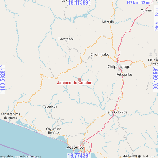
Jaleaca de Catalán GPS coordinates[2]
17° 26' 46.896" North, 99° 51' 34.848" West
| Map corner | latitude | longitude |
|---|---|---|
| Upper-left | 18.11589°, | -100.56281° |
| Center: | 17.44636°, | -99.85968° |
| Lower-right: | 16.77436°, | -99.15656° |
| Map W x H: | 149.2×149.2 km | = 92.7×92.7mi |
| max Lat: | 32.7° ⇑83.7% North |
| Jaleaca de Catalán: | 17.44636° |
| min Lat: | ⇓16.3% South 14.53588° |
| min Long | Jaleaca de Cata | max Long |
| -117.105° | -99.85968° | -86.73105° |
| W 37.8%⇐ | ⇒62.2% E |
Elevation
Elevation of Jaleaca de Catalán is 774 m = 2539 ft, and this is 479.7 m = 1574 ft below average elevation for this country.
| Max E: |
3497 m = 11473 ft | 63.6% |
| Avg. | 1253.7 m = 4113 ft | |
| Jaleaca de Catalán | 774 m = 2539 ft | |
Min E: |
-1 m = -3 ft | 36.4% |
See also: Mexico elevation on elevation.city.
Geographical zone
Jaleaca de Catalán is located in North Torrid zone (between Equator and Tropic of Cancer). Distance of this Northern Tropic circle is 666.1 km =413.9 mi to North.| Distance of | km | miles | from Jaleaca de Catalán |
|---|---|---|---|
| North Pole | 8067.2 | 5012.7 | to North |
| Arctic Circle | 5461.3 | 3393.5 | to North |
| Tropic Cancer | 666.1 | 413.9 | to North |
| Equator | 1939.9 | 1205.4 | to South |


Nearby cities:
15 places around Jaleaca de Catalán: (largest is in red/bold)
• Campo de Aviación
23.9 km =14.9 mi,  10°
10°
• Carrizal de Bravo
19.5 km =12.1 mi, 6°
• Colonia General Heliodoro Castillo (Chicahuales)
9.5 km =5.9 mi,  319°
319°
• Corral de Piedra
25.5 km =15.8 mi,  339°
339°
• El Balzamar
15.2 km =9.4 mi,  20°
20°
• Inscuinatoyac (El Pueblito)
16.3 km =10.1 mi,  122°
122°
• Iyotla
22.8 km =14.2 mi,  31°
31°
• Izotepec
18.4 km =11.4 mi,  326°
326°
• Puerto General Nicolás Bravo (Filo de Caballos)
22.5 km =14 mi,  4°
4°
• San Cristóbal
20.8 km =12.9 mi,  204°
204°
• San Vicente
20.1 km =12.5 mi,  67°
67°
• Santa Rosa de Lima
23.5 km =14.6 mi,  181°
181°
• Tepozonalco
21.5 km =13.4 mi,  35°
35°
• Tierra Colorada
5 km =3.1 mi, 42°
• Yextla
19.3 km =12 mi, 335°
Sources, notices
• [Note1] Compared only with cities in Mexico existing in our database
• [Src1] Map data: © OpenStreetMap contributors (CC-BY-SA)
• [Src2] Other city data from geonames.org with taken over terms of usage.
• [Src3] Geographical zone / Annual Mean Temperature by Robert A. Rohde @ Wikipedia
