Inscuinatoyac (El Pueblito) geodata
Inscuinatoyac (El Pueblito) (Guerrero) is a populated place; located in Mexico in America/Mexico_City (GMT-6) time zone. With population of 686 people, there are 12663 cities with bigger population in this country. Compared to other cities in Mexico, 84.5% of cities are located further ↑North; 60.6% of cities are located further →East and 67.1% of cities have higher elevation than Inscuinatoyac (El Pueblito). Note1
Current local time in Inscuinatoyac (El Pueblito):
08:35 AM, WednesdayDifference from your time zone: hours


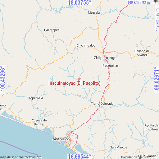
Inscuinatoyac (El Pueblito) GPS coordinates[2]
17° 22' 3.792" North, 99° 43' 47.388" West
| Map corner | latitude | longitude |
|---|---|---|
| Upper-left | 18.03755°, | -100.43296° |
| Center: | 17.36772°, | -99.72983° |
| Lower-right: | 16.69544°, | -99.02671° |
| Map W x H: | 149.2×149.2 km | = 92.7×92.7mi |
| max Lat: | 32.7° ⇑84.5% North |
| Inscuinatoyac (El Pueblito): | 17.36772° |
| min Lat: | ⇓15.5% South 14.53588° |
| min Long | Inscuinatoyac ( | max Long |
| -117.105° | -99.72983° | -86.73105° |
| W 39.4%⇐ | ⇒60.6% E |
Elevation
Elevation of Inscuinatoyac (El Pueblito) is 582 m = 1909 ft, and this is 671.7 m = 2204 ft below average elevation for this country.
| Max E: |
3497 m = 11473 ft | 67.1% |
| Avg. | 1253.7 m = 4113 ft | |
| Inscuinatoyac (El Pueblito) | 582 m = 1909 ft | |
Min E: |
-1 m = -3 ft | 32.9% |
See also: Mexico elevation on elevation.city.
Geographical zone
Inscuinatoyac (El Pueblito) is located in North Torrid zone (between Equator and Tropic of Cancer). Distance of this Northern Tropic circle is 674.8 km =419.3 mi to North.| Distance of | km | miles | from Inscuinatoyac (El Pueblito) |
|---|---|---|---|
| North Pole | 8076 | 5018.2 | to North |
| Arctic Circle | 5470.1 | 3399 | to North |
| Tropic Cancer | 674.8 | 419.3 | to North |
| Equator | 1931.1 | 1199.9 | to South |


Nearby cities:
15 places around Inscuinatoyac (El Pueblito): (largest is in red/bold)
• Coacoyulillo
9.4 km =5.8 mi,  113°
113°
• Colonia General Heliodoro Castillo (Chicahuales)
25.6 km =15.9 mi,  308°
308°
• El Balzamar
24.5 km =15.2 mi,  339°
339°
• El Fresno
16.8 km =10.4 mi,  65°
65°
• Jaleaca de Catalán
16.3 km =10.1 mi,  302°
302°
• La Esperanza
13.1 km =8.1 mi,  79°
79°
• Pablo Galeana
25.2 km =15.7 mi,  171°
171°
• San Cristóbal
24.5 km =15.2 mi,  245°
245°
• San Vicente
17 km =10.6 mi,  16°
16°
• Santa Rosa de Lima
20.6 km =12.8 mi,  224°
224°
• Tepozonalco
26.2 km =16.3 mi,  357°
357°
• Tierra Colorada
16.2 km =10.1 mi,  320°
320°
• Tlahuizapa
15.4 km =9.6 mi,  117°
117°
• Xolapa
26.1 km =16.2 mi,  151°
151°
• Zoyatepec
18.9 km =11.7 mi,  102°
102°
Sources, notices
• [Note1] Compared only with cities in Mexico existing in our database
• [Src1] Map data: © OpenStreetMap contributors (CC-BY-SA)
• [Src2] Other city data from geonames.org with taken over terms of usage.
• [Src3] Geographical zone / Annual Mean Temperature by Robert A. Rohde @ Wikipedia
