San Vicente geodata
San Vicente (Guerrero) is a populated place; located in Mexico in America/Mexico_City (GMT-6) time zone. With population of 1,888 people, there are 4608 cities with bigger population in this country. Compared to other cities in Mexico, 83% of cities are located further ↑North; 60% of cities are located further →East and 80.8% of cities have lower elevation than San Vicente. Note1


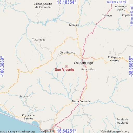
San Vicente GPS coordinates[2]
17° 30' 51.336" North, 99° 41' 1.572" West
| Map corner | latitude | longitude |
|---|---|---|
| Upper-left | 18.18354°, | -100.3869° |
| Center: | 17.51426°, | -99.68377° |
| Lower-right: | 16.84251°, | -98.98065° |
| Map W x H: | 149.1×149.1 km | = 92.6×92.6mi |
| max Lat: | 32.7° ⇑83% North |
| San Vicente: | 17.51426° |
| min Lat: | ⇓17% South 14.53588° |
| min Long | San Vicente | max Long |
| -117.105° | -99.68377° | -86.73105° |
| W 40%⇐ | ⇒60% E |
Elevation
Elevation of San Vicente is 2160 m = 7087 ft, and this is 906.3 m = 2973 ft above average elevation for this country.
| Max E: |
3497 m = 11473 ft | 19.2% |
| San Vicente | 2160 m 7087 ft | |
| Avg. | 1253.7 m = 4113 ft | |
Min E: |
-1 m = -3 ft | 80.8% |
See also: Mexico elevation on elevation.city.
Geographical zone
San Vicente is located in North Torrid zone (between Equator and Tropic of Cancer). Distance of this Northern Tropic circle is 658.5 km =409.2 mi to North.| Distance of | km | miles | from San Vicente |
|---|---|---|---|
| North Pole | 8059.7 | 5008.1 | to North |
| Arctic Circle | 5453.8 | 3388.8 | to North |
| Tropic Cancer | 658.5 | 409.2 | to North |
| Equator | 1947.4 | 1210.1 | to South |


Nearby cities:
15 places around San Vicente: (largest is in red/bold)
• Amojileca
13.6 km =8.5 mi,  63°
63°
• Atlixtac
15.5 km =9.6 mi,  21°
21°
• Carrizal de Bravo
20.1 km =12.5 mi,  305°
305°
• Chichihualco
16.1 km =10 mi,  2°
2°
• Chilpancingo
19.3 km =12 mi,  77°
77°
• Coacoyulillo
20.3 km =12.6 mi,  169°
169°
• El Balzamar
14.9 km =9.3 mi,  296°
296°
• El Fresno
13.9 km =8.6 mi,  131°
131°
• El Palmar
17.4 km =10.8 mi,  29°
29°
• Inscuinatoyac (El Pueblito)
17 km =10.6 mi,  196°
196°
• Iyotla
13.8 km =8.6 mi,  330°
330°
• Jaleaca de Catalán
20.1 km =12.5 mi,  247°
247°
• La Esperanza
16.1 km =10 mi,  150°
150°
• Tepozonalco
11.6 km =7.2 mi, 328°
• Tierra Colorada
15.7 km =9.8 mi,  255°
255°
Sources, notices
• [Note1] Compared only with cities in Mexico existing in our database
• [Src1] Map data: © OpenStreetMap contributors (CC-BY-SA)
• [Src2] Other city data from geonames.org with taken over terms of usage.
• [Src3] Geographical zone / Annual Mean Temperature by Robert A. Rohde @ Wikipedia
