El Balzamar geodata
El Balzamar (Guerrero) is a populated place; located in Mexico in America/Mexico_City (GMT-6) time zone. With population of 793 people, there are 11002 cities with bigger population in this country. Compared to other cities in Mexico, 82.4% of cities are located further ↑North; 61.6% of cities are located further →East and 78% of cities have lower elevation than El Balzamar. Note1


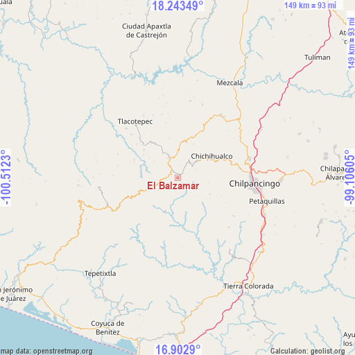
El Balzamar GPS coordinates[2]
17° 34' 27.984" North, 99° 48' 33.012" West
| Map corner | latitude | longitude |
|---|---|---|
| Upper-left | 18.24349°, | -100.5123° |
| Center: | 17.57444°, | -99.80917° |
| Lower-right: | 16.9029°, | -99.10605° |
| Map W x H: | 149.1×149.1 km | = 92.6×92.6mi |
| max Lat: | 32.7° ⇑82.4% North |
| El Balzamar: | 17.57444° |
| min Lat: | ⇓17.6% South 14.53588° |
| min Long | El Balzamar | max Long |
| -117.105° | -99.80917° | -86.73105° |
| W 38.4%⇐ | ⇒61.6% E |
Elevation
Elevation of El Balzamar is 2089 m = 6854 ft, and this is 835.3 m = 2740 ft above average elevation for this country.
| Max E: |
3497 m = 11473 ft | 22% |
| El Balzamar | 2089 m 6854 ft | |
| Avg. | 1253.7 m = 4113 ft | |
Min E: |
-1 m = -3 ft | 78% |
See also: Mexico elevation on elevation.city.
Geographical zone
El Balzamar is located in North Torrid zone (between Equator and Tropic of Cancer). Distance of this Northern Tropic circle is 651.8 km =405 mi to North.| Distance of | km | miles | from El Balzamar |
|---|---|---|---|
| North Pole | 8053 | 5003.9 | to North |
| Arctic Circle | 5447.1 | 3384.7 | to North |
| Tropic Cancer | 651.8 | 405 | to North |
| Equator | 1954.1 | 1214.2 | to South |


Nearby cities:
15 places around El Balzamar: (largest is in red/bold)
• Campo de Aviación
9.3 km =5.8 mi,  353°
353°
• Carrizal de Bravo
5.9 km =3.7 mi,  329°
329°
• Chichihualco
16.9 km =10.5 mi,  56°
56°
• Colonia General Heliodoro Castillo (Chicahuales)
13.4 km =8.3 mi,  238°
238°
• Corral de Piedra
17.2 km =10.7 mi,  304°
304°
• El Naranjo
15.8 km =9.8 mi,  25°
25°
• Huerta Vieja
18.5 km =11.5 mi,  309°
309°
• Iyotla
8.4 km =5.2 mi,  50°
50°
• Izotepec
15.4 km =9.6 mi,  274°
274°
• Jaleaca de Catalán
15.2 km =9.4 mi,  200°
200°
• Puerto General Nicolás Bravo (Filo de Caballos)
9 km =5.6 mi,  335°
335°
• San Vicente
14.9 km =9.3 mi,  116°
116°
• Tepozonalco
7.9 km =4.9 mi,  66°
66°
• Tierra Colorada
10.7 km =6.6 mi,  190°
190°
• Yextla
13.7 km =8.5 mi,  284°
284°
Sources, notices
• [Note1] Compared only with cities in Mexico existing in our database
• [Src1] Map data: © OpenStreetMap contributors (CC-BY-SA)
• [Src2] Other city data from geonames.org with taken over terms of usage.
• [Src3] Geographical zone / Annual Mean Temperature by Robert A. Rohde @ Wikipedia
