Ixcapuzalco geodata
Ixcapuzalco (Guerrero) is a seat of a second-order administrative division; located in Mexico in America/Mexico_City (GMT-6) time zone. With population of 711 people, there are 12248 cities with bigger population in this country. Compared to other cities in Mexico, 72.5% of cities are located further ↑North; 62.5% of cities are located further →East and 63% of cities have lower elevation than Ixcapuzalco. Note1


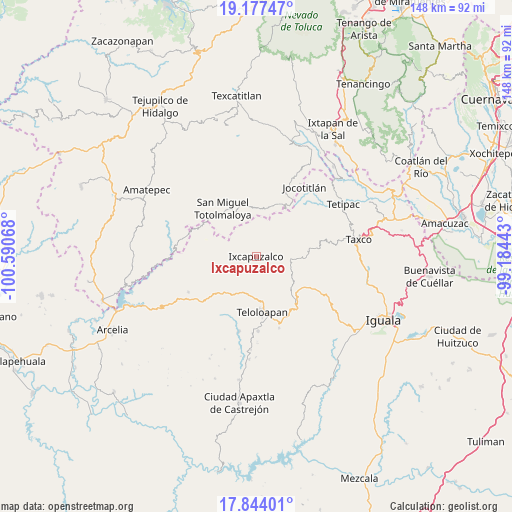
Ixcapuzalco GPS coordinates[2]
18° 30' 43.344" North, 99° 53' 15.18" West
| Map corner | latitude | longitude |
|---|---|---|
| Upper-left | 19.17747°, | -100.59068° |
| Center: | 18.51204°, | -99.88755° |
| Lower-right: | 17.84401°, | -99.18443° |
| Map W x H: | 148.3×148.3 km | = 92.1×92.1mi |
| max Lat: | 32.7° ⇑72.5% North |
| Ixcapuzalco: | 18.51204° |
| min Lat: | ⇓27.5% South 14.53588° |
| min Long | Ixcapuzalco | max Long |
| -117.105° | -99.88755° | -86.73105° |
| W 37.5%⇐ | ⇒62.5% E |
Elevation
Elevation of Ixcapuzalco is 1778 m = 5833 ft, and this is 524.3 m = 1720 ft above average elevation for this country.
| Max E: |
3497 m = 11473 ft | 37% |
| Ixcapuzalco | 1778 m 5833 ft | |
| Avg. | 1253.7 m = 4113 ft | |
Min E: |
-1 m = -3 ft | 63% |
See also: Mexico elevation on elevation.city.
Geographical zone
Ixcapuzalco is located in North Torrid zone (between Equator and Tropic of Cancer). Distance of this Northern Tropic circle is 547.6 km =340.3 mi to North.| Distance of | km | miles | from Ixcapuzalco |
|---|---|---|---|
| North Pole | 7948.7 | 4939.1 | to North |
| Arctic Circle | 5342.8 | 3319.9 | to North |
| Tropic Cancer | 547.6 | 340.3 | to North |
| Equator | 2058.3 | 1279 | to South |


Nearby cities:
15 places around Ixcapuzalco: (largest is in red/bold)
• Acapetlahuaya
22 km =13.7 mi,  242°
242°
• Acatempan
21.6 km =13.4 mi,  178°
178°
• Acatlán de la Cruz
13.9 km =8.6 mi,  201°
201°
• Atzala
23.9 km =14.9 mi,  89°
89°
• Cerro Alto
16.7 km =10.4 mi,  206°
206°
• Colonia el Pedregal
18.4 km =11.4 mi,  169°
169°
• El Capire
20.3 km =12.6 mi,  194°
194°
• Ixcateopan de Cuauhtémoc
10.2 km =6.3 mi,  96°
96°
• Jalpan (Jalpa)
18.9 km =11.7 mi,  326°
326°
• Jocotitlán
24.5 km =15.2 mi,  35°
35°
• Lídice
14.8 km =9.2 mi,  250°
250°
• San Martín Pachivia (Pachivia)
15.6 km =9.7 mi,  137°
137°
• San Pedro Hueyahualco
21 km =13 mi, 333°
• Tehuixtla
22.2 km =13.8 mi, 192°
• Teloloapan
16.3 km =10.1 mi, 174°
Sources, notices
• [Note1] Compared only with cities in Mexico existing in our database
• [Src1] Map data: © OpenStreetMap contributors (CC-BY-SA)
• [Src2] Other city data from geonames.org with taken over terms of usage.
• [Src3] Geographical zone / Annual Mean Temperature by Robert A. Rohde @ Wikipedia
