San Pedro Hueyahualco geodata
San Pedro Hueyahualco (State of Mexico) is a populated place; located in Mexico in America/Mexico_City (GMT-6) time zone. With population of 869 people, there are 10053 cities with bigger population in this country. Compared to other cities in Mexico, 70.5% of cities are located further ↑North; 63.7% of cities are located further →East and 50.6% of cities have higher elevation than San Pedro Hueyahualco. Note1
Current local time in San Pedro Hueyahualco:
08:44 AM, WednesdayDifference from your time zone: hours


San Pedro Hueyahualco GPS coordinates[2]
18° 40' 50.016" North, 99° 58' 40.008" West
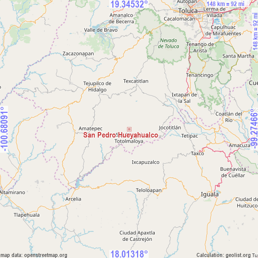
| Map corner | latitude | longitude |
|---|---|---|
| Upper-left | 19.34532°, | -100.68091° |
| Center: | 18.68056°, | -99.97778° |
| Lower-right: | 18.01318°, | -99.27466° |
| Map W x H: | 148.1×148.1 km | = 92×92mi |
| max Lat: | 32.7° ⇑70.5% North |
| San Pedro Hueyahualco: | 18.68056° |
| min Lat: | ⇓29.5% South 14.53588° |
| min Long | San Pedro Hueya | max Long |
| -117.105° | -99.97778° | -86.73105° |
| W 36.3%⇐ | ⇒63.7% E |
Elevation
Elevation of San Pedro Hueyahualco is 1399 m = 4590 ft, and this is 145.3 m = 477 ft above average elevation for this country.
| Max E: |
3497 m = 11473 ft | 50.6% |
| San Pedro Hueyahualco | 1399 m 4590 ft | |
| Avg. | 1253.7 m = 4113 ft | |
Min E: |
-1 m = -3 ft | 49.4% |
See also: Mexico elevation on elevation.city.
Geographical zone
San Pedro Hueyahualco is located in North Torrid zone (between Equator and Tropic of Cancer). Distance of this Northern Tropic circle is 528.8 km =328.6 mi to North.| Distance of | km | miles | from San Pedro Hueyahualco |
|---|---|---|---|
| North Pole | 7930 | 4927.5 | to North |
| Arctic Circle | 5324.1 | 3308.2 | to North |
| Tropic Cancer | 528.8 | 328.6 | to North |
| Equator | 2077.1 | 1290.6 | to South |


Nearby cities:
15 places around San Pedro Hueyahualco: (largest is in red/bold)
• Atzumpa
10.8 km =6.7 mi,  23°
23°
• Ayotuxco
19.6 km =12.2 mi,  69°
69°
• Capula
21.2 km =13.2 mi,  4°
4°
• Diego Sánchez
16.7 km =10.4 mi,  9°
9°
• Huitzoltepec
21 km =13 mi,  62°
62°
• Ixcapuzalco
21 km =13 mi,  153°
153°
• Jalpan (Jalpa)
3.1 km =1.9 mi,  196°
196°
• Llano Grande
21.4 km =13.3 mi,  322°
322°
• Plan de Vigas
17.1 km =10.6 mi,  36°
36°
• Potzontepec
10.9 km =6.8 mi,  54°
54°
• San Isidro Xochitla
13.3 km =8.3 mi,  341°
341°
• San Mateo (San Mateo Guayatenco)
18.9 km =11.7 mi,  253°
253°
• Santa Cruz
17 km =10.6 mi,  358°
358°
• Santa María
16.2 km =10.1 mi,  237°
237°
• Sultepec
19.8 km =12.3 mi, 3°
Sources, notices
• [Note1] Compared only with cities in Mexico existing in our database
• [Src1] Map data: © OpenStreetMap contributors (CC-BY-SA)
• [Src2] Other city data from geonames.org with taken over terms of usage.
• [Src3] Geographical zone / Annual Mean Temperature by Robert A. Rohde @ Wikipedia
