Teloloapan geodata
Teloloapan (Guerrero) is a seat of a second-order administrative division; located in Mexico in America/Mexico_City (GMT-6) time zone. With population of 23,549 people, there are 434 cities with bigger population in this country. Compared to other cities in Mexico, 74.2% of cities are located further ↑North; 62.3% of cities are located further →East and 57.1% of cities have lower elevation than Teloloapan. Note1


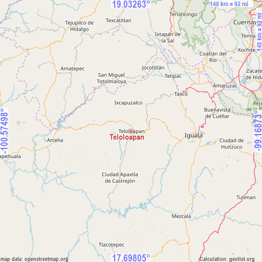
Teloloapan GPS coordinates[2]
18° 21' 59.868" North, 99° 52' 18.66" West
| Map corner | latitude | longitude |
|---|---|---|
| Upper-left | 19.03263°, | -100.57498° |
| Center: | 18.36663°, | -99.87185° |
| Lower-right: | 17.69805°, | -99.16873° |
| Map W x H: | 148.4×148.4 km | = 92.2×92.2mi |
| max Lat: | 32.7° ⇑74.2% North |
| Teloloapan: | 18.36663° |
| min Lat: | ⇓25.8% South 14.53588° |
| min Long | Teloloapan | max Long |
| -117.105° | -99.87185° | -86.73105° |
| W 37.7%⇐ | ⇒62.3% E |
Elevation
Elevation of Teloloapan is 1663 m = 5456 ft, and this is 409.3 m = 1343 ft above average elevation for this country.
| Max E: |
3497 m = 11473 ft | 42.9% |
| Teloloapan | 1663 m 5456 ft | |
| Avg. | 1253.7 m = 4113 ft | |
Min E: |
-1 m = -3 ft | 57.1% |
See also: Mexico elevation on elevation.city.
Geographical zone
Teloloapan is located in North Torrid zone (between Equator and Tropic of Cancer). Distance of this Northern Tropic circle is 563.7 km =350.3 mi to North.| Distance of | km | miles | from Teloloapan |
|---|---|---|---|
| North Pole | 7964.9 | 4949.2 | to North |
| Arctic Circle | 5359 | 3329.9 | to North |
| Tropic Cancer | 563.7 | 350.3 | to North |
| Equator | 2042.2 | 1269 | to South |


Nearby cities:
15 places around Teloloapan: (largest is in red/bold)
• Acatempan
5.5 km =3.4 mi,  192°
192°
• Acatlán de la Cruz
7.5 km =4.7 mi,  295°
295°
• Cerro Alto
9.1 km =5.7 mi,  277°
277°
• Chilacachapa
15.5 km =9.6 mi,  131°
131°
• Coatepec Costales
16.2 km =10.1 mi,  100°
100°
• Colonia el Pedregal
2.5 km =1.6 mi,  139°
139°
• El Calvario
10.4 km =6.5 mi,  145°
145°
• El Capire
7.6 km =4.7 mi,  242°
242°
• Ixcapuzalco
16.3 km =10.1 mi,  354°
354°
• Ixcateopan de Cuauhtémoc
17.2 km =10.7 mi,  29°
29°
• Los Sauces
11.8 km =7.3 mi,  160°
160°
• San Martín Pachivia (Pachivia)
10 km =6.2 mi,  62°
62°
• Tehuixtla
8.5 km =5.3 mi,  229°
229°
• Tlacaquipa
15.6 km =9.7 mi,  179°
179°
• Tlacuitlapa
17.9 km =11.1 mi, 103°
Sources, notices
• [Note1] Compared only with cities in Mexico existing in our database
• [Src1] Map data: © OpenStreetMap contributors (CC-BY-SA)
• [Src2] Other city data from geonames.org with taken over terms of usage.
• [Src3] Geographical zone / Annual Mean Temperature by Robert A. Rohde @ Wikipedia
