Acatempan geodata
Acatempan (Guerrero) is a populated place; located in Mexico in America/Mexico_City (GMT-6) time zone. With population of 1,391 people, there are 6222 cities with bigger population in this country. Compared to other cities in Mexico, 74.7% of cities are located further ↑North; 62.4% of cities are located further →East and 57% of cities have lower elevation than Acatempan. Note1


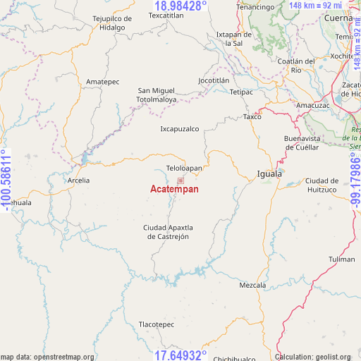
Acatempan GPS coordinates[2]
18° 19' 5.124" North, 99° 52' 58.728" West
| Map corner | latitude | longitude |
|---|---|---|
| Upper-left | 18.98428°, | -100.58611° |
| Center: | 18.31809°, | -99.88298° |
| Lower-right: | 17.64932°, | -99.17986° |
| Map W x H: | 148.4×148.4 km | = 92.2×92.2mi |
| max Lat: | 32.7° ⇑74.7% North |
| Acatempan: | 18.31809° |
| min Lat: | ⇓25.3% South 14.53588° |
| min Long | Acatempan | max Long |
| -117.105° | -99.88298° | -86.73105° |
| W 37.6%⇐ | ⇒62.4% E |
Elevation
Elevation of Acatempan is 1657 m = 5436 ft, and this is 403.3 m = 1323 ft above average elevation for this country.
| Max E: |
3497 m = 11473 ft | 43% |
| Acatempan | 1657 m 5436 ft | |
| Avg. | 1253.7 m = 4113 ft | |
Min E: |
-1 m = -3 ft | 57% |
See also: Mexico elevation on elevation.city.
Geographical zone
Acatempan is located in North Torrid zone (between Equator and Tropic of Cancer). Distance of this Northern Tropic circle is 569.1 km =353.6 mi to North.| Distance of | km | miles | from Acatempan |
|---|---|---|---|
| North Pole | 7970.3 | 4952.5 | to North |
| Arctic Circle | 5364.4 | 3333.3 | to North |
| Tropic Cancer | 569.1 | 353.6 | to North |
| Equator | 2036.8 | 1265.6 | to South |


Nearby cities:
15 places around Acatempan: (largest is in red/bold)
• Acatlán de la Cruz
10.3 km =6.4 mi,  327°
327°
• Apetlanca
15.8 km =9.8 mi,  140°
140°
• Cerro Alto
10.3 km =6.4 mi,  310°
310°
• Chilacachapa
13.7 km =8.5 mi,  110°
110°
• Colonia el Pedregal
4.5 km =2.8 mi,  38°
38°
• Cuaxilotla
16.6 km =10.3 mi,  168°
168°
• El Calvario
7.8 km =4.8 mi, 113°
• El Capire
5.8 km =3.6 mi,  288°
288°
• Los Sauces
7.6 km =4.7 mi, 138°
• Oxtotitlán
15.2 km =9.4 mi,  200°
200°
• San Martín Pachivia (Pachivia)
14.2 km =8.8 mi,  45°
45°
• Tehuixtla
5.3 km =3.3 mi,  268°
268°
• Teloloapan
5.5 km =3.4 mi,  12°
12°
• Tianquizolco
17.1 km =10.6 mi,  127°
127°
• Tlacaquipa
10.3 km =6.4 mi, 173°
Sources, notices
• [Note1] Compared only with cities in Mexico existing in our database
• [Src1] Map data: © OpenStreetMap contributors (CC-BY-SA)
• [Src2] Other city data from geonames.org with taken over terms of usage.
• [Src3] Geographical zone / Annual Mean Temperature by Robert A. Rohde @ Wikipedia
