Colonia el Pedregal geodata
Colonia el Pedregal (Guerrero) is a populated place; located in Mexico in America/Mexico_City (GMT-6) time zone. With population of 1,551 people, there are 5558 cities with bigger population in this country. Compared to other cities in Mexico, 74.3% of cities are located further ↑North; 62.2% of cities are located further →East and 55.9% of cities have lower elevation than Colonia el Pedregal. Note1


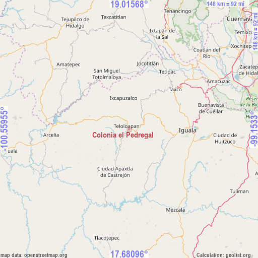
Colonia el Pedregal GPS coordinates[2]
18° 20' 58.596" North, 99° 51' 23.112" West
| Map corner | latitude | longitude |
|---|---|---|
| Upper-left | 19.01568°, | -100.55955° |
| Center: | 18.34961°, | -99.85642° |
| Lower-right: | 17.68096°, | -99.1533° |
| Map W x H: | 148.4×148.4 km | = 92.2×92.2mi |
| max Lat: | 32.7° ⇑74.3% North |
| Colonia el Pedregal: | 18.34961° |
| min Lat: | ⇓25.7% South 14.53588° |
| min Long | Colonia el Pedr | max Long |
| -117.105° | -99.85642° | -86.73105° |
| W 37.8%⇐ | ⇒62.2% E |
Elevation
Elevation of Colonia el Pedregal is 1617 m = 5305 ft, and this is 363.3 m = 1192 ft above average elevation for this country.
| Max E: |
3497 m = 11473 ft | 44.1% |
| Colonia el Pedregal | 1617 m 5305 ft | |
| Avg. | 1253.7 m = 4113 ft | |
Min E: |
-1 m = -3 ft | 55.9% |
See also: Mexico elevation on elevation.city.
Geographical zone
Colonia el Pedregal is located in North Torrid zone (between Equator and Tropic of Cancer). Distance of this Northern Tropic circle is 565.6 km =351.4 mi to North.| Distance of | km | miles | from Colonia el Pedregal |
|---|---|---|---|
| North Pole | 7966.8 | 4950.3 | to North |
| Arctic Circle | 5360.9 | 3331.1 | to North |
| Tropic Cancer | 565.6 | 351.4 | to North |
| Equator | 2040.3 | 1267.8 | to South |


Nearby cities:
15 places around Colonia el Pedregal: (largest is in red/bold)
• Acatempan
4.5 km =2.8 mi,  218°
218°
• Acatlán de la Cruz
9.8 km =6.1 mi,  301°
301°
• Apetlanca
17.3 km =10.7 mi,  155°
155°
• Cerro Alto
11.1 km =6.9 mi,  286°
286°
• Chilacachapa
13.1 km =8.1 mi,  130°
130°
• Coatepec Costales
14.3 km =8.9 mi,  94°
94°
• El Calvario
7.9 km =4.9 mi,  146°
146°
• El Capire
8.5 km =5.3 mi,  258°
258°
• Los Sauces
9.5 km =5.9 mi,  166°
166°
• San Martín Pachivia (Pachivia)
9.8 km =6.1 mi,  47°
47°
• Tehuixtla
8.9 km =5.5 mi,  245°
245°
• Teloloapan
2.5 km =1.6 mi,  319°
319°
• Tlacaquipa
13.8 km =8.6 mi,  186°
186°
• Tlacuitlapa
15.9 km =9.9 mi,  98°
98°
• Tonalapa del Río
17.4 km =10.8 mi, 92°
Sources, notices
• [Note1] Compared only with cities in Mexico existing in our database
• [Src1] Map data: © OpenStreetMap contributors (CC-BY-SA)
• [Src2] Other city data from geonames.org with taken over terms of usage.
• [Src3] Geographical zone / Annual Mean Temperature by Robert A. Rohde @ Wikipedia
