Lídice geodata
Lídice (Guerrero) is a populated place; located in Mexico in America/Mexico_City (GMT-6) time zone. With population of 767 people, there are 11411 cities with bigger population in this country. Compared to other cities in Mexico, 73% of cities are located further ↑North; 64.2% of cities are located further →East and 55.7% of cities have higher elevation than Lídice. Note1


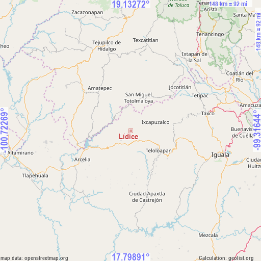
Lídice GPS coordinates[2]
18° 28' 1.596" North, 100° 1' 10.416" West
| Map corner | latitude | longitude |
|---|---|---|
| Upper-left | 19.13272°, | -100.72269° |
| Center: | 18.46711°, | -100.01956° |
| Lower-right: | 17.79891°, | -99.31644° |
| Map W x H: | 148.3×148.3 km | = 92.1×92.1mi |
| max Lat: | 32.7° ⇑73% North |
| Lídice: | 18.46711° |
| min Lat: | ⇓27% South 14.53588° |
| min Long | Lídice | max Long |
| -117.105° | -100.01956° | -86.73105° |
| W 35.8%⇐ | ⇒64.2% E |
Elevation
Elevation of Lídice is 1170 m = 3839 ft, and this is 83.7 m = 275 ft below average elevation for this country.
| Max E: |
3497 m = 11473 ft | 55.7% |
| Avg. | 1253.7 m = 4113 ft | |
| Lídice | 1170 m = 3839 ft | |
Min E: |
-1 m = -3 ft | 44.3% |
See also: Mexico elevation on elevation.city.
Geographical zone
Lídice is located in North Torrid zone (between Equator and Tropic of Cancer). Distance of this Northern Tropic circle is 552.6 km =343.4 mi to North.| Distance of | km | miles | from Lídice |
|---|---|---|---|
| North Pole | 7953.7 | 4942.2 | to North |
| Arctic Circle | 5347.8 | 3323 | to North |
| Tropic Cancer | 552.6 | 343.4 | to North |
| Equator | 2053.4 | 1275.9 | to South |


Nearby cities:
15 places around Lídice: (largest is in red/bold)
• Acapetlahuaya
7.7 km =4.8 mi,  226°
226°
• Acatempan
22 km =13.7 mi,  138°
138°
• Acatlán de la Cruz
11.9 km =7.4 mi,  131°
131°
• Almoloya
19.8 km =12.3 mi,  236°
236°
• Cerro Alto
11.9 km =7.4 mi,  146°
146°
• Colonia el Pedregal
21.6 km =13.4 mi, 127°
• El Capire
17.2 km =10.7 mi, 148°
• Ixcapuzalco
14.8 km =9.2 mi,  70°
70°
• Jalpan (Jalpa)
21 km =13 mi,  9°
9°
• San Mateo (San Mateo Guayatenco)
23.1 km =14.4 mi,  323°
323°
• San Pedro Hueyahualco
24.1 km =15 mi, 10°
• Santa María
17.6 km =10.9 mi,  328°
328°
• Tehuixtla
19 km =11.8 mi, 151°
• Teloloapan
19.2 km =11.9 mi, 125°
• Totoltepec
21.4 km =13.3 mi,  186°
186°
Sources, notices
• [Note1] Compared only with cities in Mexico existing in our database
• [Src1] Map data: © OpenStreetMap contributors (CC-BY-SA)
• [Src2] Other city data from geonames.org with taken over terms of usage.
• [Src3] Geographical zone / Annual Mean Temperature by Robert A. Rohde @ Wikipedia
