Chamulapa geodata
Chamulapa (Chiapas) is a populated place; located in Mexico in America/Mexico_City (GMT-6) time zone. With population of 701 people, there are 12418 cities with bigger population in this country. Compared to other cities in Mexico, 99.3% of cities are located further ↑North; 92.7% of cities are located further ←West and 86.7% of cities have higher elevation than Chamulapa. Note1


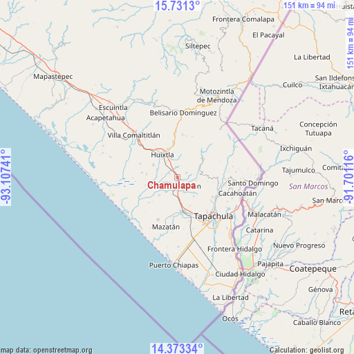
Chamulapa GPS coordinates[2]
15° 3' 12.24" North, 92° 24' 15.408" West
| Map corner | latitude | longitude |
|---|---|---|
| Upper-left | 15.7313°, | -93.10741° |
| Center: | 15.0534°, | -92.40428° |
| Lower-right: | 14.37334°, | -91.70116° |
| Map W x H: | 151×151 km | = 93.8×93.8mi |
| max Lat: | 32.7° ⇑99.3% North |
| Chamulapa: | 15.0534° |
| min Lat: | ⇓0.7% South 14.53588° |
| min Long | Chamulapa | max Long |
| -117.105° | -92.40428° | -86.73105° |
| W 92.7%⇐ | ⇒7.3% E |
Elevation
Elevation of Chamulapa is 35 m = 115 ft, and this is 1218.7 m = 3998 ft below average elevation for this country.
| Max E: |
3497 m = 11473 ft | 86.7% |
| Avg. | 1253.7 m = 4113 ft | |
| Chamulapa | 35 m = 115 ft | |
Min E: |
-1 m = -3 ft | 13.3% |
See also: Mexico elevation on elevation.city.
Geographical zone
Chamulapa is located in North Torrid zone (between Equator and Tropic of Cancer). Distance of this Northern Tropic circle is 932.1 km =579.2 mi to North.| Distance of | km | miles | from Chamulapa |
|---|---|---|---|
| North Pole | 8333.3 | 5178.1 | to North |
| Arctic Circle | 5727.4 | 3558.8 | to North |
| Tropic Cancer | 932.1 | 579.2 | to North |
| Equator | 1673.8 | 1040.1 | to South |


Nearby cities:
15 places around Chamulapa: (largest is in red/bold)
• Cantón la Lima
4.5 km =2.8 mi,  226°
226°
• Chamulapita
4.1 km =2.5 mi,  65°
65°
• Cuarto Cantón
5.8 km =3.6 mi,  315°
315°
• Cuntalapa
3.1 km =1.9 mi,  165°
165°
• Cuyamiapa
2.4 km =1.5 mi,  220°
220°
• El Chipilín
7.9 km =4.9 mi,  341°
341°
• Estación Huehuetán
4.7 km =2.9 mi,  183°
183°
• Estación Tuzantán
7.7 km =4.8 mi, 319°
• Guachipilín
8.3 km =5.2 mi,  200°
200°
• Huehuetán
4.4 km =2.7 mi,  147°
147°
• Nueva Victoria
8.3 km =5.2 mi,  243°
243°
• Primer Cantón
8.4 km =5.2 mi,  332°
332°
• San José el Amate
7.4 km =4.6 mi,  208°
208°
• Segundo Cantón
6.2 km =3.9 mi, 327°
• Villa Hidalgo
6.7 km =4.2 mi,  28°
28°
Sources, notices
• [Note1] Compared only with cities in Mexico existing in our database
• [Src1] Map data: © OpenStreetMap contributors (CC-BY-SA)
• [Src2] Other city data from geonames.org with taken over terms of usage.
• [Src3] Geographical zone / Annual Mean Temperature by Robert A. Rohde @ Wikipedia
