Huehuetán geodata
Huehuetán (Chiapas) is a seat of a second-order administrative division; located in Mexico in America/Mexico_City (GMT-6) time zone. With population of 7,755 people, there are 1201 cities with bigger population in this country. Compared to other cities in Mexico, 99.5% of cities are located further ↑North; 92.9% of cities are located further ←West and 82.6% of cities have higher elevation than Huehuetán. Note1


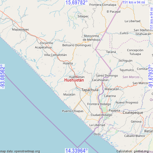
Huehuetán GPS coordinates[2]
15° 1' 11.316" North, 92° 22' 56.964" West
| Map corner | latitude | longitude |
|---|---|---|
| Upper-left | 15.69782°, | -93.08562° |
| Center: | 15.01981°, | -92.38249° |
| Lower-right: | 14.33964°, | -91.67937° |
| Map W x H: | 151×151 km | = 93.8×93.8mi |
| max Lat: | 32.7° ⇑99.5% North |
| Huehuetán: | 15.01981° |
| min Lat: | ⇓0.5% South 14.53588° |
| min Long | Huehuetán | max Long |
| -117.105° | -92.38249° | -86.73105° |
| W 92.9%⇐ | ⇒7.1% E |
Elevation
Elevation of Huehuetán is 64 m = 210 ft, and this is 1189.7 m = 3903 ft below average elevation for this country.
| Max E: |
3497 m = 11473 ft | 82.6% |
| Avg. | 1253.7 m = 4113 ft | |
| Huehuetán | 64 m = 210 ft | |
Min E: |
-1 m = -3 ft | 17.4% |
See also: Mexico elevation on elevation.city.
Geographical zone
Huehuetán is located in North Torrid zone (between Equator and Tropic of Cancer). Distance of this Northern Tropic circle is 935.9 km =581.5 mi to North.| Distance of | km | miles | from Huehuetán |
|---|---|---|---|
| North Pole | 8337 | 5180.4 | to North |
| Arctic Circle | 5731.1 | 3561.1 | to North |
| Tropic Cancer | 935.9 | 581.5 | to North |
| Equator | 1670 | 1037.7 | to South |


Nearby cities:
15 places around Huehuetán: (largest is in red/bold)
• Cantón la Lima
5.6 km =3.5 mi,  276°
276°
• Chamulapa
4.4 km =2.7 mi,  327°
327°
• Chamulapita
5.6 km =3.5 mi,  14°
14°
• Cuarto Cantón
10.2 km =6.3 mi,  320°
320°
• Cuntalapa
1.8 km =1.1 mi,  295°
295°
• Cuyamiapa
4.3 km =2.7 mi, 296°
• El Edén
9.9 km =6.2 mi,  63°
63°
• Estación Huehuetán
2.8 km =1.7 mi,  249°
249°
• Guachipilín
6.6 km =4.1 mi,  232°
232°
• Guadalupe
6.4 km =4 mi,  133°
133°
• Nueva Victoria
9.8 km =6.1 mi,  269°
269°
• Nuevo Pumpuapa (Cereso)
10.6 km =6.6 mi,  170°
170°
• San José el Amate
6.5 km =4 mi, 245°
• Unión Miramar
9 km =5.6 mi,  158°
158°
• Villa Hidalgo
9.7 km =6 mi, 5°
Sources, notices
• [Note1] Compared only with cities in Mexico existing in our database
• [Src1] Map data: © OpenStreetMap contributors (CC-BY-SA)
• [Src2] Other city data from geonames.org with taken over terms of usage.
• [Src3] Geographical zone / Annual Mean Temperature by Robert A. Rohde @ Wikipedia
