Pathé geodata
Pathé (Querétaro) is a populated place; located in Mexico in America/Mexico_City (GMT-6) time zone. With population of 663 people, there are 13102 cities with bigger population in this country. Compared to other cities in Mexico, 70% of cities are located further ↓South; 60.2% of cities are located further →East and 62.7% of cities have lower elevation than Pathé. Note1


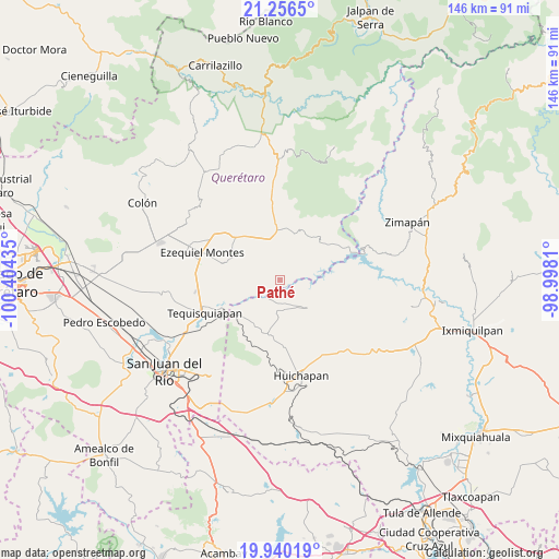
Pathé GPS coordinates[2]
20° 35' 59.172" North, 99° 42' 4.392" West
| Map corner | latitude | longitude |
|---|---|---|
| Upper-left | 21.2565°, | -100.40435° |
| Center: | 20.59977°, | -99.70122° |
| Lower-right: | 19.94019°, | -98.9981° |
| Map W x H: | 146.4×146.4 km | = 91×91mi |
| max Lat: | 32.7° ⇑30% North |
| Pathé: | 20.59977° |
| min Lat: | ⇓70% South 14.53588° |
| min Long | Pathé | max Long |
| -117.105° | -99.70122° | -86.73105° |
| W 39.8%⇐ | ⇒60.2% E |
Elevation
Elevation of Pathé is 1773 m = 5817 ft, and this is 519.3 m = 1704 ft above average elevation for this country.
| Max E: |
3497 m = 11473 ft | 37.3% |
| Pathé | 1773 m 5817 ft | |
| Avg. | 1253.7 m = 4113 ft | |
Min E: |
-1 m = -3 ft | 62.7% |
See also: Mexico elevation on elevation.city.
Geographical zone
Pathé is located in North Torrid zone (between Equator and Tropic of Cancer). Distance of this Northern Tropic circle is 315.4 km =196 mi to North.| Distance of | km | miles | from Pathé |
|---|---|---|---|
| North Pole | 7716.6 | 4794.9 | to North |
| Arctic Circle | 5110.7 | 3175.6 | to North |
| Tropic Cancer | 315.4 | 196 | to North |
| Equator | 2290.5 | 1423.3 | to South |


Nearby cities:
15 places around Pathé: (largest is in red/bold)
• Banzha
12 km =7.5 mi,  95°
95°
• Bomanxotha
10 km =6.2 mi,  159°
159°
• Boyecito
2.3 km =1.4 mi,  126°
126°
• Boyé
9.9 km =6.2 mi,  336°
336°
• El Palmar
10.4 km =6.5 mi,  357°
357°
• El Riíto
7.8 km =4.8 mi,  108°
108°
• Gandhó
6.2 km =3.9 mi,  166°
166°
• La Esquina
5.9 km =3.7 mi,  186°
186°
• La Mesilla
12.5 km =7.8 mi, 168°
• Pañhé
8.7 km =5.4 mi,  176°
176°
• Portezuelo
4 km =2.5 mi,  262°
262°
• San Antonio
7.6 km =4.7 mi, 187°
• Tecozautla
10.1 km =6.3 mi,  136°
136°
• Tenzabhí
12.4 km =7.7 mi,  148°
148°
• Uxdejhé
4.2 km =2.6 mi,  120°
120°
Sources, notices
• [Note1] Compared only with cities in Mexico existing in our database
• [Src1] Map data: © OpenStreetMap contributors (CC-BY-SA)
• [Src2] Other city data from geonames.org with taken over terms of usage.
• [Src3] Geographical zone / Annual Mean Temperature by Robert A. Rohde @ Wikipedia
