Boca de Lima geodata
Boca de Lima (Veracruz) is a populated place; located in Mexico in America/Mexico_City (GMT-6) time zone. With population of 737 people, there are 11858 cities with bigger population in this country. Compared to other cities in Mexico, 69% of cities are located further ↓South; 73.2% of cities are located further ←West and 96.3% of cities have higher elevation than Boca de Lima. Note1


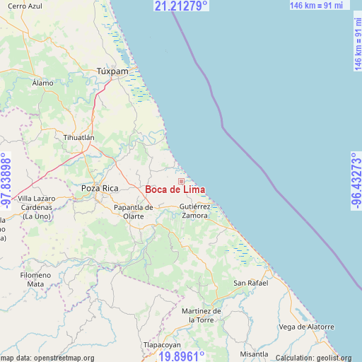
Boca de Lima GPS coordinates[2]
20° 33' 21.096" North, 97° 8' 9.06" West
| Map corner | latitude | longitude |
|---|---|---|
| Upper-left | 21.21279°, | -97.83898° |
| Center: | 20.55586°, | -97.13585° |
| Lower-right: | 19.8961°, | -96.43273° |
| Map W x H: | 146.4×146.4 km | = 91×91mi |
| max Lat: | 32.7° ⇑31% North |
| Boca de Lima: | 20.55586° |
| min Lat: | ⇓69% South 14.53588° |
| min Long | Boca de Lima | max Long |
| -117.105° | -97.13585° | -86.73105° |
| W 73.2%⇐ | ⇒26.8% E |
Elevation
Elevation of Boca de Lima is 11 m = 36 ft, and this is 1242.7 m = 4077 ft below average elevation for this country.
| Max E: |
3497 m = 11473 ft | 96.3% |
| Avg. | 1253.7 m = 4113 ft | |
| Boca de Lima | 11 m = 36 ft | |
Min E: |
-1 m = -3 ft | 3.7% |
See also: Mexico elevation on elevation.city.
Geographical zone
Boca de Lima is located in North Torrid zone (between Equator and Tropic of Cancer). Distance of this Northern Tropic circle is 320.3 km =199 mi to North.| Distance of | km | miles | from Boca de Lima |
|---|---|---|---|
| North Pole | 7721.5 | 4797.9 | to North |
| Arctic Circle | 5115.6 | 3178.7 | to North |
| Tropic Cancer | 320.3 | 199 | to North |
| Equator | 2285.6 | 1420.2 | to South |


Nearby cities:
15 places around Boca de Lima: (largest is in red/bold)
• Anclón y Arenal
13.6 km =8.5 mi,  171°
171°
• Carrizal
13.3 km =8.3 mi,  289°
289°
• El Cedro
11.4 km =7.1 mi,  220°
220°
• El Volador
15.2 km =9.4 mi,  309°
309°
• Gutiérrez Zamora
12.5 km =7.8 mi,  155°
155°
• Hermenegildo Galeana
10.3 km =6.4 mi,  191°
191°
• La Guásima
12 km =7.5 mi,  261°
261°
• Nuevo Renacimiento 2000
14.9 km =9.3 mi,  153°
153°
• Polutla
13.2 km =8.2 mi, 256°
• Poza Verde
12.3 km =7.6 mi,  278°
278°
• Puente de Piedra
8.3 km =5.2 mi, 311°
• Rancho Nuevo
14.9 km =9.3 mi,  330°
330°
• San Pablo
11.9 km =7.4 mi,  209°
209°
• Tecolutla
15.3 km =9.5 mi,  123°
123°
• Tenixtepec
6 km =3.7 mi, 289°
Sources, notices
• [Note1] Compared only with cities in Mexico existing in our database
• [Src1] Map data: © OpenStreetMap contributors (CC-BY-SA)
• [Src2] Other city data from geonames.org with taken over terms of usage.
• [Src3] Geographical zone / Annual Mean Temperature by Robert A. Rohde @ Wikipedia
