Telchac Puerto geodata
Telchac Puerto (Yucatán) is a seat of a second-order administrative division; located in Mexico in America/Merida (GMT-6) time zone. With population of 1,722 people, there are 5040 cities with bigger population in this country. Compared to other cities in Mexico, 80.4% of cities are located further ↓South; 98.5% of cities are located further ←West and 99.6% of cities have higher elevation than Telchac Puerto. Note1


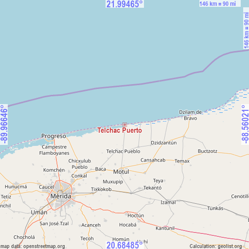
Telchac Puerto GPS coordinates[2]
21° 20' 28.356" North, 89° 15' 47.988" West
| Map corner | latitude | longitude |
|---|---|---|
| Upper-left | 21.99465°, | -89.96646° |
| Center: | 21.34121°, | -89.26333° |
| Lower-right: | 20.68485°, | -88.56021° |
| Map W x H: | 145.6×145.6 km | = 90.5×90.5mi |
| max Lat: | 32.7° ⇑19.6% North |
| Telchac Puerto: | 21.34121° |
| min Lat: | ⇓80.4% South 14.53588° |
| min Long | Telchac Puerto | max Long |
| -117.105° | -89.26333° | -86.73105° |
| W 98.5%⇐ | ⇒1.5% E |
Elevation
Elevation of Telchac Puerto is 4 m = 13 ft, and this is 1249.7 m = 4100 ft below average elevation for this country.
| Max E: |
3497 m = 11473 ft | 99.6% |
| Avg. | 1253.7 m = 4113 ft | |
| Telchac Puerto | 4 m = 13 ft | |
Min E: |
-1 m = -3 ft | 0.4% |
See also: Mexico elevation on elevation.city.
Geographical zone
Telchac Puerto is located in North Torrid zone (between Equator and Tropic of Cancer). Distance of this Northern Tropic circle is 233 km =144.8 mi to North.| Distance of | km | miles | from Telchac Puerto |
|---|---|---|---|
| North Pole | 7634.1 | 4743.6 | to North |
| Arctic Circle | 5028.3 | 3124.4 | to North |
| Tropic Cancer | 233 | 144.8 | to North |
| Equator | 2372.9 | 1474.5 | to South |


Nearby cities:
15 places around Telchac Puerto: (largest is in red/bold)
• Cansahcab
26.4 km =16.4 mi,  140°
140°
• Dzemul
15.3 km =9.5 mi,  198°
198°
• Dzidzantun
25.1 km =15.6 mi,  114°
114°
• Kancabal
25.7 km =16 mi,  179°
179°
• Kini
23.5 km =14.6 mi,  193°
193°
• Sacapuc
21.8 km =13.5 mi,  206°
206°
• San Crisanto
9.2 km =5.7 mi,  81°
81°
• San Francisco Manzanilla
26.8 km =16.7 mi, 111°
• San Pedro Chacabal
24.1 km =15 mi,  162°
162°
• Sinanche
15.2 km =9.4 mi,  147°
147°
• Tanya
25.6 km =15.9 mi, 176°
• Telchac Pueblo
15.4 km =9.6 mi, 182°
• Timul
21.1 km =13.1 mi,  218°
218°
• Uci
23.8 km =14.8 mi, 181°
• Yobain
19.4 km =12.1 mi,  127°
127°
Sources, notices
• [Note1] Compared only with cities in Mexico existing in our database
• [Src1] Map data: © OpenStreetMap contributors (CC-BY-SA)
• [Src2] Other city data from geonames.org with taken over terms of usage.
• [Src3] Geographical zone / Annual Mean Temperature by Robert A. Rohde @ Wikipedia
