Coetzapotitla geodata
Coetzapotitla (Veracruz) is a populated place; located in Mexico in America/Mexico_City (GMT-6) time zone. With population of 813 people, there are 10742 cities with bigger population in this country. Compared to other cities in Mexico, 69.4% of cities are located further ↑North; 75.8% of cities are located further ←West and 54.4% of cities have higher elevation than Coetzapotitla. Note1


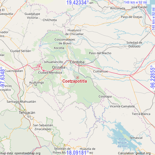
Coetzapotitla GPS coordinates[2]
18° 45' 32.004" North, 96° 55' 54.012" West
| Map corner | latitude | longitude |
|---|---|---|
| Upper-left | 19.42334°, | -97.6348° |
| Center: | 18.75889°, | -96.93167° |
| Lower-right: | 18.09181°, | -96.22855° |
| Map W x H: | 148.1×148.1 km | = 92×92mi |
| max Lat: | 32.7° ⇑69.4% North |
| Coetzapotitla: | 18.75889° |
| min Lat: | ⇓30.6% South 14.53588° |
| min Long | Coetzapotitla | max Long |
| -117.105° | -96.93167° | -86.73105° |
| W 75.8%⇐ | ⇒24.2% E |
Elevation
Elevation of Coetzapotitla is 1224 m = 4016 ft, and this is 29.7 m = 97 ft below average elevation for this country.
| Max E: |
3497 m = 11473 ft | 54.4% |
| Avg. | 1253.7 m = 4113 ft | |
| Coetzapotitla | 1224 m = 4016 ft | |
Min E: |
-1 m = -3 ft | 45.6% |
See also: Mexico elevation on elevation.city.
Geographical zone
Coetzapotitla is located in North Torrid zone (between Equator and Tropic of Cancer). Distance of this Northern Tropic circle is 520.1 km =323.2 mi to North.| Distance of | km | miles | from Coetzapotitla |
|---|---|---|---|
| North Pole | 7921.3 | 4922.1 | to North |
| Arctic Circle | 5315.4 | 3302.8 | to North |
| Tropic Cancer | 520.1 | 323.2 | to North |
| Equator | 2085.8 | 1296.1 | to South |


Nearby cities:
15 places around Coetzapotitla: (largest is in red/bold)
• Choapa
4.1 km =2.5 mi,  231°
231°
• Coetzala
3.3 km =2.1 mi,  27°
27°
• Cotlaixco
2.1 km =1.3 mi,  297°
297°
• El Campanario
4.8 km =3 mi,  279°
279°
• El Otate
6.2 km =3.9 mi,  38°
38°
• Emiliano Zapata
1.2 km =0.7 mi,  214°
214°
• Guadalupe
6.4 km =4 mi,  6°
6°
• Naranjal
6.6 km =4.1 mi,  330°
330°
• Poxcautla
5.2 km =3.2 mi,  250°
250°
• Rincón de Buena Vista
6.6 km =4.1 mi,  93°
93°
• San José Independencia
1.4 km =0.9 mi,  256°
256°
• San Sebastián
3.7 km =2.3 mi,  193°
193°
• Tenejápam de Mata
5.5 km =3.4 mi,  74°
74°
• Tlecuaxco
6.4 km =4 mi,  269°
269°
• Villa Libertad
6.7 km =4.2 mi,  336°
336°
Sources, notices
• [Note1] Compared only with cities in Mexico existing in our database
• [Src1] Map data: © OpenStreetMap contributors (CC-BY-SA)
• [Src2] Other city data from geonames.org with taken over terms of usage.
• [Src3] Geographical zone / Annual Mean Temperature by Robert A. Rohde @ Wikipedia
