La Escalera geodata
La Escalera (Oaxaca) is a populated place; located in Mexico in America/Mexico_City (GMT-6) time zone. With population of 781 people, there are 11181 cities with bigger population in this country. Compared to other cities in Mexico, 94.6% of cities are located further ↑North; 79.2% of cities are located further ←West and 57.3% of cities have lower elevation than La Escalera. Note1


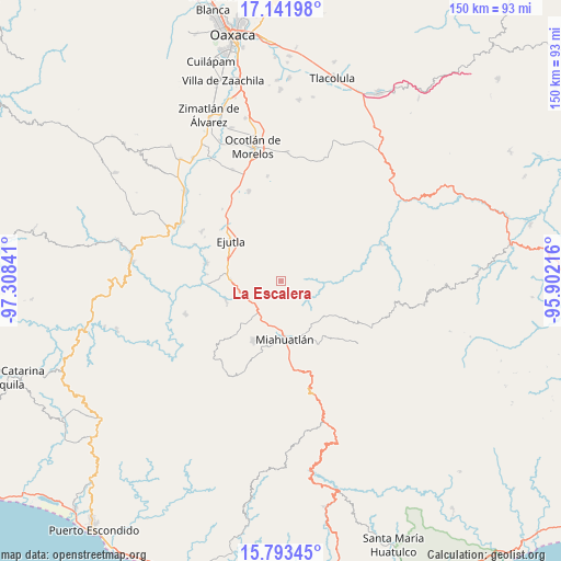
La Escalera GPS coordinates[2]
16° 28' 8.004" North, 96° 36' 19.008" West
| Map corner | latitude | longitude |
|---|---|---|
| Upper-left | 17.14198°, | -97.30841° |
| Center: | 16.46889°, | -96.60528° |
| Lower-right: | 15.79345°, | -95.90216° |
| Map W x H: | 149.9×149.9 km | = 93.1×93.1mi |
| max Lat: | 32.7° ⇑94.6% North |
| La Escalera: | 16.46889° |
| min Lat: | ⇓5.4% South 14.53588° |
| min Long | La Escalera | max Long |
| -117.105° | -96.60528° | -86.73105° |
| W 79.2%⇐ | ⇒20.8% E |
Elevation
Elevation of La Escalera is 1669 m = 5476 ft, and this is 415.3 m = 1363 ft above average elevation for this country.
| Max E: |
3497 m = 11473 ft | 42.7% |
| La Escalera | 1669 m 5476 ft | |
| Avg. | 1253.7 m = 4113 ft | |
Min E: |
-1 m = -3 ft | 57.3% |
See also: Mexico elevation on elevation.city.
Geographical zone
La Escalera is located in North Torrid zone (between Equator and Tropic of Cancer). Distance of this Northern Tropic circle is 774.8 km =481.4 mi to North.| Distance of | km | miles | from La Escalera |
|---|---|---|---|
| North Pole | 8175.9 | 5080.3 | to North |
| Arctic Circle | 5570 | 3461 | to North |
| Tropic Cancer | 774.8 | 481.4 | to North |
| Equator | 1831.2 | 1137.9 | to South |


Nearby cities:
15 places around La Escalera: (largest is in red/bold)
• Agua del Sol
13.4 km =8.3 mi,  271°
271°
• Barranca Larga
13.8 km =8.6 mi,  281°
281°
• Coatecas Altas
10.3 km =6.4 mi,  319°
319°
• El Cerro de las Huertas
14.9 km =9.3 mi, 316°
• El Zompantle
7.4 km =4.6 mi,  246°
246°
• Guixé
10.4 km =6.5 mi, 270°
• La Soledad
5.4 km =3.4 mi,  199°
199°
• Monjas
11.7 km =7.3 mi, 199°
• San Esteban Amatlán
7.1 km =4.4 mi,  56°
56°
• San Juán Lachigalla
14.6 km =9.1 mi,  23°
23°
• San Luis Amatlán
14.6 km =9.1 mi,  128°
128°
• San Simón Almolongas
14 km =8.7 mi,  240°
240°
• Santa María Velato
5.8 km =3.6 mi,  312°
312°
• Santiago la Libertad
13 km =8.1 mi,  36°
36°
• Sitio de Xitlapehua
15.2 km =9.4 mi,  149°
149°
Sources, notices
• [Note1] Compared only with cities in Mexico existing in our database
• [Src1] Map data: © OpenStreetMap contributors (CC-BY-SA)
• [Src2] Other city data from geonames.org with taken over terms of usage.
• [Src3] Geographical zone / Annual Mean Temperature by Robert A. Rohde @ Wikipedia
