Chiltoyac geodata
Chiltoyac (Veracruz) is a populated place; located in Mexico in America/Mexico_City (GMT-6) time zone. With population of 2,458 people, there are 3598 cities with bigger population in this country. Compared to other cities in Mexico, 52.5% of cities are located further ↑North; 76.5% of cities are located further ←West and 59% of cities have higher elevation than Chiltoyac. Note1


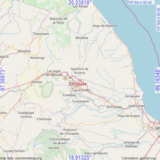
Chiltoyac GPS coordinates[2]
19° 34' 37.488" North, 96° 51' 59.76" West
| Map corner | latitude | longitude |
|---|---|---|
| Upper-left | 20.23818°, | -97.56973° |
| Center: | 19.57708°, | -96.8666° |
| Lower-right: | 18.91325°, | -96.16348° |
| Map W x H: | 147.3×147.3 km | = 91.5×91.5mi |
| max Lat: | 32.7° ⇑52.5% North |
| Chiltoyac: | 19.57708° |
| min Lat: | ⇓47.5% South 14.53588° |
| min Long | Chiltoyac | max Long |
| -117.105° | -96.8666° | -86.73105° |
| W 76.5%⇐ | ⇒23.5% E |
Elevation
Elevation of Chiltoyac is 1051 m = 3448 ft, and this is 202.7 m = 665 ft below average elevation for this country.
| Max E: |
3497 m = 11473 ft | 59% |
| Avg. | 1253.7 m = 4113 ft | |
| Chiltoyac | 1051 m = 3448 ft | |
Min E: |
-1 m = -3 ft | 41% |
See also: Mexico elevation on elevation.city.
Geographical zone
Chiltoyac is located in North Torrid zone (between Equator and Tropic of Cancer). Distance of this Northern Tropic circle is 429.2 km =266.7 mi to North.| Distance of | km | miles | from Chiltoyac |
|---|---|---|---|
| North Pole | 7830.3 | 4865.5 | to North |
| Arctic Circle | 5224.4 | 3246.3 | to North |
| Tropic Cancer | 429.2 | 266.7 | to North |
| Equator | 2176.8 | 1352.6 | to South |


Nearby cities:
15 places around Chiltoyac: (largest is in red/bold)
• Banderilla
7.5 km =4.7 mi,  280°
280°
• El Castillo
3.4 km =2.1 mi,  175°
175°
• El Espinal
5.3 km =3.3 mi,  353°
353°
• El Pueblito (Garbanzal)
6.3 km =3.9 mi,  287°
287°
• La Concepción
4.8 km =3 mi,  312°
312°
• La Haciendita
4.1 km =2.5 mi,  264°
264°
• Las Haldas
7.2 km =4.5 mi,  37°
37°
• Las Lomas
6.9 km =4.3 mi,  317°
317°
• San Antonio Paso del Toro
3.1 km =1.9 mi,  76°
76°
• Seis de Enero
3.7 km =2.3 mi,  106°
106°
• Tenampa
3.9 km =2.4 mi,  7°
7°
• Tronconal
1.5 km =0.9 mi,  166°
166°
• Vicente Guerrero (Tepetates)
7.2 km =4.5 mi,  59°
59°
• Xalapa de Enríquez
7.3 km =4.5 mi,  225°
225°
• Xaltepec
7.3 km =4.5 mi, 290°
Sources, notices
• [Note1] Compared only with cities in Mexico existing in our database
• [Src1] Map data: © OpenStreetMap contributors (CC-BY-SA)
• [Src2] Other city data from geonames.org with taken over terms of usage.
• [Src3] Geographical zone / Annual Mean Temperature by Robert A. Rohde @ Wikipedia
