San Antonio Paso del Toro geodata
San Antonio Paso del Toro (Veracruz) is a populated place; located in Mexico in America/Mexico_City (GMT-6) time zone. With population of 535 people, there are 15842 cities with bigger population in this country. Compared to other cities in Mexico, 52.3% of cities are located further ↑North; 76.8% of cities are located further ←West and 62.3% of cities have higher elevation than San Antonio Paso del Toro. Note1
Current local time in San Antonio Paso del Toro:
10:04 AM, MondayDifference from your time zone: hours


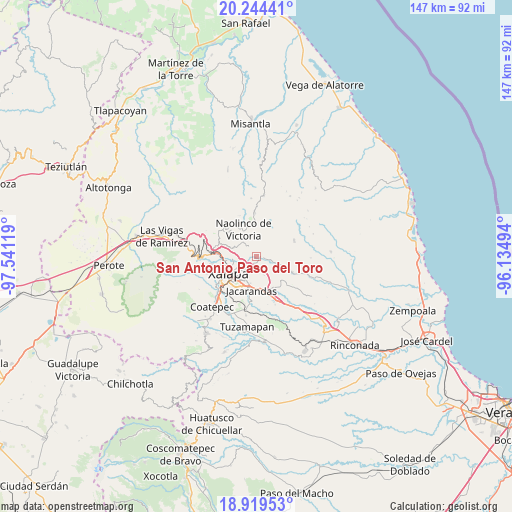
San Antonio Paso del Toro GPS coordinates[2]
19° 34' 59.988" North, 96° 50' 17.016" West
| Map corner | latitude | longitude |
|---|---|---|
| Upper-left | 20.24441°, | -97.54119° |
| Center: | 19.58333°, | -96.83806° |
| Lower-right: | 18.91953°, | -96.13494° |
| Map W x H: | 147.3×147.3 km | = 91.5×91.5mi |
| max Lat: | 32.7° ⇑52.3% North |
| San Antonio Paso del Toro: | 19.58333° |
| min Lat: | ⇓47.7% South 14.53588° |
| min Long | San Antonio Pas | max Long |
| -117.105° | -96.83806° | -86.73105° |
| W 76.8%⇐ | ⇒23.2% E |
Elevation
Elevation of San Antonio Paso del Toro is 865 m = 2838 ft, and this is 388.7 m = 1275 ft below average elevation for this country.
| Max E: |
3497 m = 11473 ft | 62.3% |
| Avg. | 1253.7 m = 4113 ft | |
| San Antonio Paso del Toro | 865 m = 2838 ft | |
Min E: |
-1 m = -3 ft | 37.7% |
See also: Mexico elevation on elevation.city.
Geographical zone
San Antonio Paso del Toro is located in North Torrid zone (between Equator and Tropic of Cancer). Distance of this Northern Tropic circle is 428.5 km =266.3 mi to North.| Distance of | km | miles | from San Antonio Paso del Toro |
|---|---|---|---|
| North Pole | 7829.6 | 4865.1 | to North |
| Arctic Circle | 5223.7 | 3245.9 | to North |
| Tropic Cancer | 428.5 | 266.3 | to North |
| Equator | 2177.5 | 1353 | to South |


Nearby cities:
15 places around San Antonio Paso del Toro: (largest is in red/bold)
• Almolonga
5.8 km =3.6 mi,  82°
82°
• Chiltoyac
3.1 km =1.9 mi,  256°
256°
• El Castillo
4.9 km =3 mi,  213°
213°
• El Espinal
5.8 km =3.6 mi,  321°
321°
• El Terrero
6.6 km =4.1 mi,  141°
141°
• La Concepción
7 km =4.3 mi,  291°
291°
• La Haciendita
7.1 km =4.4 mi, 261°
• Las Haldas
5.2 km =3.2 mi,  15°
15°
• Las Lomas
8.8 km =5.5 mi,  299°
299°
• Naolinco de Victoria
8.8 km =5.5 mi,  335°
335°
• San Nicolás
7.8 km =4.8 mi,  112°
112°
• Seis de Enero
1.8 km =1.1 mi,  162°
162°
• Tenampa
4 km =2.5 mi, 321°
• Tronconal
3.4 km =2.1 mi,  230°
230°
• Vicente Guerrero (Tepetates)
4.4 km =2.7 mi,  46°
46°
Sources, notices
• [Note1] Compared only with cities in Mexico existing in our database
• [Src1] Map data: © OpenStreetMap contributors (CC-BY-SA)
• [Src2] Other city data from geonames.org with taken over terms of usage.
• [Src3] Geographical zone / Annual Mean Temperature by Robert A. Rohde @ Wikipedia
