Vicente Guerrero (Tepetates) geodata
Vicente Guerrero (Tepetates) (Veracruz) is a populated place; located in Mexico in America/Mexico_City (GMT-6) time zone. With population of 935 people, there are 9320 cities with bigger population in this country. Compared to other cities in Mexico, 51.7% of cities are located further ↑North; 77.2% of cities are located further ←West and 61.5% of cities have higher elevation than Vicente Guerrero (Tepetates). Note1
Current local time in Vicente Guerrero (Tepetates):
09:49 PM, TuesdayDifference from your time zone: hours


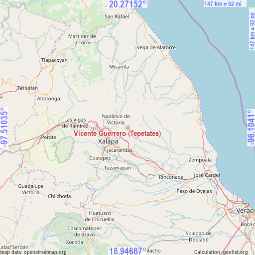
Vicente Guerrero (Tepetates) GPS coordinates[2]
19° 36' 38.016" North, 96° 48' 25.992" West
| Map corner | latitude | longitude |
|---|---|---|
| Upper-left | 20.27152°, | -97.51035° |
| Center: | 19.61056°, | -96.80722° |
| Lower-right: | 18.94687°, | -96.1041° |
| Map W x H: | 147.3×147.3 km | = 91.5×91.5mi |
| max Lat: | 32.7° ⇑51.7% North |
| Vicente Guerrero (Tepetates): | 19.61056° |
| min Lat: | ⇓48.3% South 14.53588° |
| min Long | Vicente Guerrer | max Long |
| -117.105° | -96.80722° | -86.73105° |
| W 77.2%⇐ | ⇒22.8% E |
Elevation
Elevation of Vicente Guerrero (Tepetates) is 909 m = 2982 ft, and this is 344.7 m = 1131 ft below average elevation for this country.
| Max E: |
3497 m = 11473 ft | 61.5% |
| Avg. | 1253.7 m = 4113 ft | |
| Vicente Guerrero (Tepetates) | 909 m = 2982 ft | |
Min E: |
-1 m = -3 ft | 38.5% |
See also: Mexico elevation on elevation.city.
Geographical zone
Vicente Guerrero (Tepetates) is located in North Torrid zone (between Equator and Tropic of Cancer). Distance of this Northern Tropic circle is 425.4 km =264.3 mi to North.| Distance of | km | miles | from Vicente Guerrero (Tepetates) |
|---|---|---|---|
| North Pole | 7826.6 | 4863.2 | to North |
| Arctic Circle | 5220.7 | 3244 | to North |
| Tropic Cancer | 425.4 | 264.3 | to North |
| Equator | 2180.5 | 1354.9 | to South |


Nearby cities:
15 places around Vicente Guerrero (Tepetates): (largest is in red/bold)
• Almolonga
3.3 km =2.1 mi,  132°
132°
• Alto Lucero
7.8 km =4.8 mi,  78°
78°
• Cerrillos de Diaz
8.8 km =5.5 mi, 76°
• Chiltoyac
7.2 km =4.5 mi,  239°
239°
• El Espinal
7 km =4.3 mi,  282°
282°
• El Terrero
8.2 km =5.1 mi,  174°
174°
• Las Haldas
2.7 km =1.7 mi,  317°
317°
• Mafafas
7.6 km =4.7 mi,  45°
45°
• Naolinco de Victoria
8.5 km =5.3 mi,  305°
305°
• San Antonio Paso del Toro
4.4 km =2.7 mi,  226°
226°
• San Nicolás
7.3 km =4.5 mi,  146°
146°
• Seis de Enero
5.5 km =3.4 mi,  209°
209°
• Tenampa
5.7 km =3.5 mi,  271°
271°
• Tepetlán
7 km =4.3 mi,  8°
8°
• Tronconal
7.8 km =4.8 mi, 228°
Sources, notices
• [Note1] Compared only with cities in Mexico existing in our database
• [Src1] Map data: © OpenStreetMap contributors (CC-BY-SA)
• [Src2] Other city data from geonames.org with taken over terms of usage.
• [Src3] Geographical zone / Annual Mean Temperature by Robert A. Rohde @ Wikipedia
