Chikindzonot geodata
Chikindzonot (Yucatán) is a populated place; located in Mexico in America/Merida (GMT-6) time zone. With population of 2,699 people, there are 3280 cities with bigger population in this country. Compared to other cities in Mexico, 64.2% of cities are located further ↓South; 99.3% of cities are located further ←West and 88% of cities have higher elevation than Chikindzonot. Note1


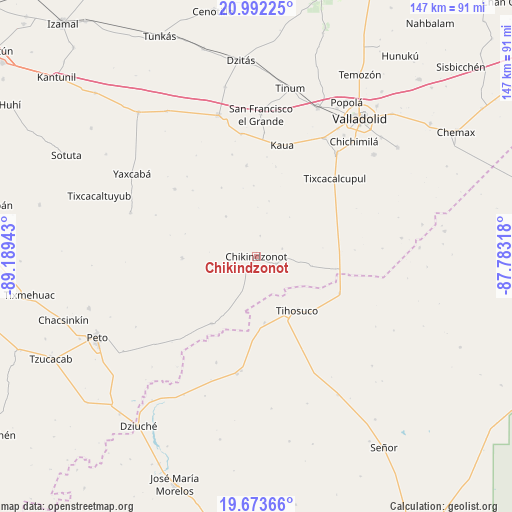
Chikindzonot GPS coordinates[2]
20° 20' 3.696" North, 88° 29' 10.68" West
| Map corner | latitude | longitude |
|---|---|---|
| Upper-left | 20.99225°, | -89.18943° |
| Center: | 20.33436°, | -88.4863° |
| Lower-right: | 19.67366°, | -87.78318° |
| Map W x H: | 146.6×146.6 km | = 91.1×91.1mi |
| max Lat: | 32.7° ⇑35.8% North |
| Chikindzonot: | 20.33436° |
| min Lat: | ⇓64.2% South 14.53588° |
| min Long | Chikindzonot | max Long |
| -117.105° | -88.4863° | -86.73105° |
| W 99.3%⇐ | ⇒0.7% E |
Elevation
Elevation of Chikindzonot is 30 m = 98 ft, and this is 1223.7 m = 4015 ft below average elevation for this country.
| Max E: |
3497 m = 11473 ft | 88% |
| Avg. | 1253.7 m = 4113 ft | |
| Chikindzonot | 30 m = 98 ft | |
Min E: |
-1 m = -3 ft | 12% |
See also: Mexico elevation on elevation.city.
Geographical zone
Chikindzonot is located in North Torrid zone (between Equator and Tropic of Cancer). Distance of this Northern Tropic circle is 345 km =214.4 mi to North.| Distance of | km | miles | from Chikindzonot |
|---|---|---|---|
| North Pole | 7746.1 | 4813.2 | to North |
| Arctic Circle | 5140.2 | 3194 | to North |
| Tropic Cancer | 345 | 214.4 | to North |
| Equator | 2261 | 1404.9 | to South |


Nearby cities:
15 places around Chikindzonot: (largest is in red/bold)
• Ekpedz
6.1 km =3.8 mi,  108°
108°
• Huay Max
32.8 km =20.4 mi,  187°
187°
• Ichmul
22.9 km =14.2 mi,  213°
213°
• Kancabdzonot
30.4 km =18.9 mi,  309°
309°
• Kaua
32.8 km =20.4 mi,  12°
12°
• Tepich
26 km =16.2 mi, 113°
• Ticimul
30.1 km =18.7 mi,  346°
346°
• Tiholop
21.2 km =13.2 mi,  269°
269°
• Tihosuco
19.3 km =12 mi,  142°
142°
• Tixcacalcupul
31.8 km =19.8 mi,  45°
45°
• X Cabil
18.9 km =11.7 mi,  172°
172°
• Xcalak Dzonot
14.6 km =9.1 mi,  323°
323°
• Xcopteil
22.3 km =13.9 mi,  333°
333°
• Yaxunah
30.3 km =18.8 mi, 319°
• Zacalaca
32.3 km =20.1 mi,  200°
200°
Sources, notices
• [Note1] Compared only with cities in Mexico existing in our database
• [Src1] Map data: © OpenStreetMap contributors (CC-BY-SA)
• [Src2] Other city data from geonames.org with taken over terms of usage.
• [Src3] Geographical zone / Annual Mean Temperature by Robert A. Rohde @ Wikipedia
