Tiholop geodata
Tiholop (Yucatán) is a populated place; located in Mexico in America/Merida (GMT-6) time zone. With population of 1,463 people, there are 5904 cities with bigger population in this country. Compared to other cities in Mexico, 64.2% of cities are located further ↓South; 99.1% of cities are located further ←West and 88% of cities have higher elevation than Tiholop. Note1


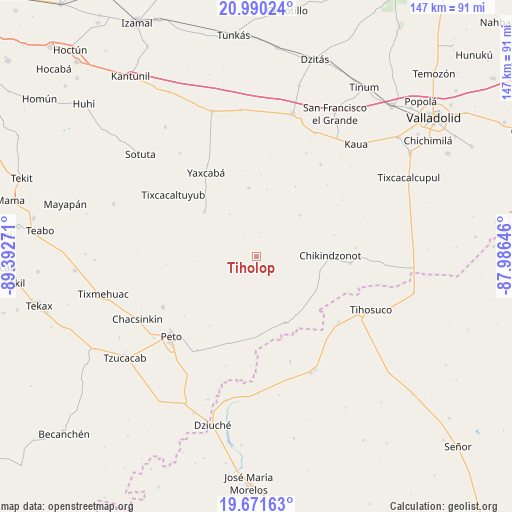
Tiholop GPS coordinates[2]
20° 19' 56.424" North, 88° 41' 22.488" West
| Map corner | latitude | longitude |
|---|---|---|
| Upper-left | 20.99024°, | -89.39271° |
| Center: | 20.33234°, | -88.68958° |
| Lower-right: | 19.67163°, | -87.98646° |
| Map W x H: | 146.6×146.6 km | = 91.1×91.1mi |
| max Lat: | 32.7° ⇑35.8% North |
| Tiholop: | 20.33234° |
| min Lat: | ⇓64.2% South 14.53588° |
| min Long | Tiholop | max Long |
| -117.105° | -88.68958° | -86.73105° |
| W 99.1%⇐ | ⇒0.90000000000001% E |
Elevation
Elevation of Tiholop is 30 m = 98 ft, and this is 1223.7 m = 4015 ft below average elevation for this country.
| Max E: |
3497 m = 11473 ft | 88% |
| Avg. | 1253.7 m = 4113 ft | |
| Tiholop | 30 m = 98 ft | |
Min E: |
-1 m = -3 ft | 12% |
See also: Mexico elevation on elevation.city.
Geographical zone
Tiholop is located in North Torrid zone (between Equator and Tropic of Cancer). Distance of this Northern Tropic circle is 345.2 km =214.5 mi to North.| Distance of | km | miles | from Tiholop |
|---|---|---|---|
| North Pole | 7746.3 | 4813.3 | to North |
| Arctic Circle | 5140.4 | 3194.1 | to North |
| Tropic Cancer | 345.2 | 214.5 | to North |
| Equator | 2260.7 | 1404.7 | to South |


Nearby cities:
15 places around Tiholop: (largest is in red/bold)
• Chikindzonot
21.2 km =13.2 mi,  89°
89°
• Ekpedz
27.1 km =16.8 mi, 93°
• Ichmul
20.7 km =12.9 mi,  155°
155°
• Kancabdzonot
19.8 km =12.3 mi,  353°
353°
• Tahdzibichen
19.6 km =12.2 mi,  311°
311°
• Tahdziu
30.2 km =18.8 mi,  242°
242°
• Ticimul
32.8 km =20.4 mi,  25°
25°
• Timul
26 km =16.2 mi,  264°
264°
• Tixcacaltuyub
29.6 km =18.4 mi, 307°
• X Cabil
30 km =18.6 mi,  128°
128°
• Xcalak Dzonot
17.3 km =10.7 mi,  46°
46°
• Xcopteil
23.1 km =14.4 mi, 29°
• Yaxcabá
28 km =17.4 mi,  329°
329°
• Yaxunah
23.3 km =14.5 mi,  3°
3°
• Zacalaca
31.6 km =19.6 mi, 161°
Sources, notices
• [Note1] Compared only with cities in Mexico existing in our database
• [Src1] Map data: © OpenStreetMap contributors (CC-BY-SA)
• [Src2] Other city data from geonames.org with taken over terms of usage.
• [Src3] Geographical zone / Annual Mean Temperature by Robert A. Rohde @ Wikipedia
