San Buenaventura geodata
San Buenaventura (State of Mexico) is a populated place; located in Mexico in America/Mexico_City (GMT-6) time zone. With population of 44,761 people, there are 241 cities with bigger population in this country. Compared to other cities in Mexico, 58.8% of cities are located further ↑North; 52.5% of cities are located further ←West and 85.9% of cities have lower elevation than San Buenaventura. Note1


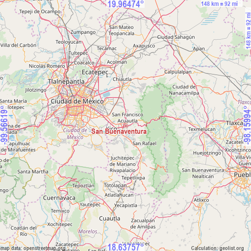
San Buenaventura GPS coordinates[2]
19° 18' 9" North, 98° 51' 47.016" West
| Map corner | latitude | longitude |
|---|---|---|
| Upper-left | 19.96474°, | -99.56619° |
| Center: | 19.3025°, | -98.86306° |
| Lower-right: | 18.63757°, | -98.15994° |
| Map W x H: | 147.6×147.6 km | = 91.7×91.7mi |
| max Lat: | 32.7° ⇑58.8% North |
| San Buenaventura: | 19.3025° |
| min Lat: | ⇓41.2% South 14.53588° |
| min Long | San Buenaventur | max Long |
| -117.105° | -98.86306° | -86.73105° |
| W 52.5%⇐ | ⇒47.5% E |
Elevation
Elevation of San Buenaventura is 2278 m = 7474 ft, and this is 1024.3 m = 3361 ft above average elevation for this country.
| Max E: |
3497 m = 11473 ft | 14.1% |
| San Buenaventura | 2278 m 7474 ft | |
| Avg. | 1253.7 m = 4113 ft | |
Min E: |
-1 m = -3 ft | 85.9% |
See also: San Buenaventura elevation on elevation.city.
Geographical zone
San Buenaventura is located in North Torrid zone (between Equator and Tropic of Cancer). Distance of this Northern Tropic circle is 459.7 km =285.6 mi to North.| Distance of | km | miles | from San Buenaventura |
|---|---|---|---|
| North Pole | 7860.8 | 4884.5 | to North |
| Arctic Circle | 5254.9 | 3265.2 | to North |
| Tropic Cancer | 459.7 | 285.6 | to North |
| Equator | 2146.2 | 1333.6 | to South |


Nearby cities:
15 places around San Buenaventura: (largest is in red/bold)
• Ampliación 6 de Junio
7.6 km =4.7 mi,  300°
300°
• Chalco
5.8 km =3.6 mi,  218°
218°
• Ex-Hacienda de Guadalupe
6.5 km =4 mi,  163°
163°
• Ixtapaluca
2.5 km =1.6 mi, 304°
• Jorge Jiménez Cantú
1.9 km =1.2 mi,  64°
64°
• La Candelaria Tlapala
7.1 km =4.4 mi,  166°
166°
• Los Hornos
6.1 km =3.8 mi,  4°
4°
• San Francisco Acuautla
4.8 km =3 mi, 3°
• San Gregorio Cuautzingo
4.8 km =3 mi, 172°
• San Jerónimo Cuatro Vientos
2.5 km =1.6 mi,  115°
115°
• San Lucas Amalinalco
3.6 km =2.2 mi,  181°
181°
• San Marcos Huixtoco
0.7 km =0.4 mi,  185°
185°
• San Martín Cuautlalpan
4.4 km =2.7 mi,  131°
131°
• Santa María Huexoculco
6.7 km =4.2 mi,  137°
137°
• Zoquiapan
2.2 km =1.4 mi,  39°
39°
Sources, notices
• [Note1] Compared only with cities in Mexico existing in our database
• [Src1] Map data: © OpenStreetMap contributors (CC-BY-SA)
• [Src2] Other city data from geonames.org with taken over terms of usage.
• [Src3] Geographical zone / Annual Mean Temperature by Robert A. Rohde @ Wikipedia
