Caxhuacán geodata
Caxhuacán (Puebla) is a seat of a second-order administrative division; located in Mexico in America/Mexico_City (GMT-6) time zone. With population of 3,383 people, there are 2685 cities with bigger population in this country. Compared to other cities in Mexico, 58.4% of cities are located further ↓South; 68.4% of cities are located further ←West and 64.8% of cities have higher elevation than Caxhuacán. Note1


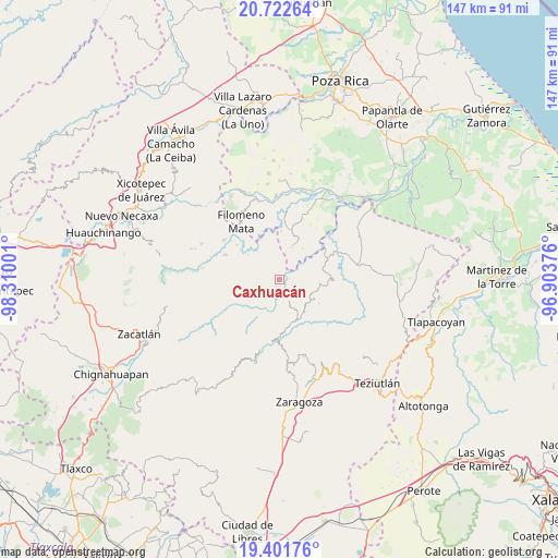
Caxhuacán GPS coordinates[2]
20° 3' 48.924" North, 97° 36' 24.768" West
| Map corner | latitude | longitude |
|---|---|---|
| Upper-left | 20.72264°, | -98.31001° |
| Center: | 20.06359°, | -97.60688° |
| Lower-right: | 19.40176°, | -96.90376° |
| Map W x H: | 146.9×146.9 km | = 91.3×91.3mi |
| max Lat: | 32.7° ⇑41.6% North |
| Caxhuacán: | 20.06359° |
| min Lat: | ⇓58.4% South 14.53588° |
| min Long | Caxhuacán | max Long |
| -117.105° | -97.60688° | -86.73105° |
| W 68.4%⇐ | ⇒31.6% E |
Elevation
Elevation of Caxhuacán is 700 m = 2297 ft, and this is 553.7 m = 1817 ft below average elevation for this country.
| Max E: |
3497 m = 11473 ft | 64.8% |
| Avg. | 1253.7 m = 4113 ft | |
| Caxhuacán | 700 m = 2297 ft | |
Min E: |
-1 m = -3 ft | 35.2% |
See also: Mexico elevation on elevation.city.
Geographical zone
Caxhuacán is located in North Torrid zone (between Equator and Tropic of Cancer). Distance of this Northern Tropic circle is 375.1 km =233.1 mi to North.| Distance of | km | miles | from Caxhuacán |
|---|---|---|---|
| North Pole | 7776.2 | 4831.9 | to North |
| Arctic Circle | 5170.3 | 3212.7 | to North |
| Tropic Cancer | 375.1 | 233.1 | to North |
| Equator | 2230.9 | 1386.2 | to South |


Nearby cities:
15 places around Caxhuacán: (largest is in red/bold)
• Acatzácatl
5.7 km =3.5 mi,  23°
23°
• Atlequizayan
6 km =3.7 mi,  197°
197°
• Chilocoyo del Carmen
5.4 km =3.4 mi,  290°
290°
• Ecatlán (Santiago Ecatlán)
5.4 km =3.4 mi,  102°
102°
• Escatachuchut
3.3 km =2.1 mi,  253°
253°
• Francisco I. Madero
4.9 km =3 mi,  9°
9°
• Huehuetla
5.1 km =3.2 mi,  337°
337°
• Jonotla
5 km =3.1 mi,  138°
138°
• Kuwik Chuchut
5.4 km =3.4 mi,  355°
355°
• Leacaman
5.4 km =3.4 mi,  315°
315°
• Lipuntahuaca
3.9 km =2.4 mi, 321°
• Ozelonacaxtla
2 km =1.2 mi, 202°
• Putaxcat
3.8 km =2.4 mi,  330°
330°
• Tuzamapan
3.3 km =2.1 mi,  85°
85°
• Zozocolco de Guerrero
6 km =3.7 mi,  41°
41°
Sources, notices
• [Note1] Compared only with cities in Mexico existing in our database
• [Src1] Map data: © OpenStreetMap contributors (CC-BY-SA)
• [Src2] Other city data from geonames.org with taken over terms of usage.
• [Src3] Geographical zone / Annual Mean Temperature by Robert A. Rohde @ Wikipedia
