Escatachuchut geodata
Escatachuchut (Puebla) is a populated place; located in Mexico in America/Mexico_City (GMT-6) time zone. With population of 543 people, there are 15651 cities with bigger population in this country. Compared to other cities in Mexico, 58.1% of cities are located further ↓South; 68% of cities are located further ←West and 61.4% of cities have higher elevation than Escatachuchut. Note1


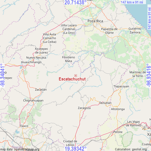
Escatachuchut GPS coordinates[2]
20° 3' 19.044" North, 97° 38' 14.208" West
| Map corner | latitude | longitude |
|---|---|---|
| Upper-left | 20.71438°, | -98.34041° |
| Center: | 20.05529°, | -97.63728° |
| Lower-right: | 19.39342°, | -96.93416° |
| Map W x H: | 146.9×146.9 km | = 91.3×91.3mi |
| max Lat: | 32.7° ⇑41.9% North |
| Escatachuchut: | 20.05529° |
| min Lat: | ⇓58.1% South 14.53588° |
| min Long | Escatachuchut | max Long |
| -117.105° | -97.63728° | -86.73105° |
| W 68%⇐ | ⇒32% E |
Elevation
Elevation of Escatachuchut is 914 m = 2999 ft, and this is 339.7 m = 1115 ft below average elevation for this country.
| Max E: |
3497 m = 11473 ft | 61.4% |
| Avg. | 1253.7 m = 4113 ft | |
| Escatachuchut | 914 m = 2999 ft | |
Min E: |
-1 m = -3 ft | 38.6% |
See also: Mexico elevation on elevation.city.
Geographical zone
Escatachuchut is located in North Torrid zone (between Equator and Tropic of Cancer). Distance of this Northern Tropic circle is 376 km =233.6 mi to North.| Distance of | km | miles | from Escatachuchut |
|---|---|---|---|
| North Pole | 7777.1 | 4832.5 | to North |
| Arctic Circle | 5171.2 | 3213.2 | to North |
| Tropic Cancer | 376 | 233.6 | to North |
| Equator | 2229.9 | 1385.6 | to South |


Nearby cities:
15 places around Escatachuchut: (largest is in red/bold)
• Atlequizayan
5 km =3.1 mi,  164°
164°
• Caxhuacán
3.3 km =2.1 mi,  73°
73°
• Chilocoyo del Carmen
3.3 km =2.1 mi,  326°
326°
• Chipahuatlán
5.4 km =3.4 mi,  276°
276°
• Huehuetla
5.8 km =3.6 mi,  12°
12°
• Ignacio Allende (Concepción)
5 km =3.1 mi,  176°
176°
• Ixtepec
3.5 km =2.2 mi,  195°
195°
• Leacaman
4.9 km =3 mi,  352°
352°
• Lipuntahuaca
4.1 km =2.5 mi, 10°
• Ozelonacaxtla
2.6 km =1.6 mi,  112°
112°
• Putaxcat
4.4 km =2.7 mi,  16°
16°
• San Martín
5.3 km =3.3 mi,  185°
185°
• Tuxtla
6.4 km =4 mi, 197°
• Tuzamapan
6.6 km =4.1 mi,  79°
79°
• Zitlala
3.9 km =2.4 mi,  234°
234°
Sources, notices
• [Note1] Compared only with cities in Mexico existing in our database
• [Src1] Map data: © OpenStreetMap contributors (CC-BY-SA)
• [Src2] Other city data from geonames.org with taken over terms of usage.
• [Src3] Geographical zone / Annual Mean Temperature by Robert A. Rohde @ Wikipedia
