Ozelonacaxtla geodata
Ozelonacaxtla (Puebla) is a populated place; located in Mexico in America/Mexico_City (GMT-6) time zone. With population of 1,326 people, there are 6543 cities with bigger population in this country. Compared to other cities in Mexico, 57.9% of cities are located further ↓South; 68.3% of cities are located further ←West and 62.5% of cities have higher elevation than Ozelonacaxtla. Note1


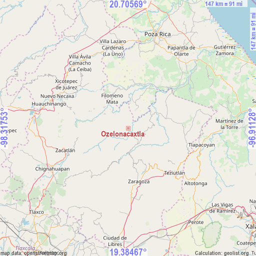
Ozelonacaxtla GPS coordinates[2]
20° 2' 47.652" North, 97° 36' 51.84" West
| Map corner | latitude | longitude |
|---|---|---|
| Upper-left | 20.70569°, | -98.31753° |
| Center: | 20.04657°, | -97.6144° |
| Lower-right: | 19.38467°, | -96.91128° |
| Map W x H: | 146.9×146.9 km | = 91.3×91.3mi |
| max Lat: | 32.7° ⇑42.1% North |
| Ozelonacaxtla: | 20.04657° |
| min Lat: | ⇓57.9% South 14.53588° |
| min Long | Ozelonacaxtla | max Long |
| -117.105° | -97.6144° | -86.73105° |
| W 68.3%⇐ | ⇒31.7% E |
Elevation
Elevation of Ozelonacaxtla is 856 m = 2808 ft, and this is 397.7 m = 1305 ft below average elevation for this country.
| Max E: |
3497 m = 11473 ft | 62.5% |
| Avg. | 1253.7 m = 4113 ft | |
| Ozelonacaxtla | 856 m = 2808 ft | |
Min E: |
-1 m = -3 ft | 37.5% |
See also: Mexico elevation on elevation.city.
Geographical zone
Ozelonacaxtla is located in North Torrid zone (between Equator and Tropic of Cancer). Distance of this Northern Tropic circle is 376.9 km =234.2 mi to North.| Distance of | km | miles | from Ozelonacaxtla |
|---|---|---|---|
| North Pole | 7778.1 | 4833.1 | to North |
| Arctic Circle | 5172.2 | 3213.9 | to North |
| Tropic Cancer | 376.9 | 234.2 | to North |
| Equator | 2229 | 1385 | to South |


Nearby cities:
15 places around Ozelonacaxtla: (largest is in red/bold)
• Atlequizayan
4 km =2.5 mi,  195°
195°
• Caxhuacán
2 km =1.2 mi,  22°
22°
• Chilocoyo del Carmen
5.7 km =3.5 mi,  311°
311°
• Ecatlán (Santiago Ecatlán)
6 km =3.7 mi,  83°
83°
• Escatachuchut
2.6 km =1.6 mi,  292°
292°
• Ignacio Allende (Concepción)
4.5 km =2.8 mi,  207°
207°
• Ixtepec
4.1 km =2.5 mi,  233°
233°
• Jonotla
4.5 km =2.8 mi,  113°
113°
• Leacaman
6.5 km =4 mi,  332°
332°
• Lipuntahuaca
5.2 km =3.2 mi,  341°
341°
• Putaxcat
5.3 km =3.3 mi,  347°
347°
• San Martín
5.2 km =3.2 mi, 213°
• Tuzamapan
4.6 km =2.9 mi,  62°
62°
• Zitlala
5.8 km =3.6 mi,  257°
257°
• Zoquiopan
4.6 km =2.9 mi,  155°
155°
Sources, notices
• [Note1] Compared only with cities in Mexico existing in our database
• [Src1] Map data: © OpenStreetMap contributors (CC-BY-SA)
• [Src2] Other city data from geonames.org with taken over terms of usage.
• [Src3] Geographical zone / Annual Mean Temperature by Robert A. Rohde @ Wikipedia
