Cañada Blanca geodata
Cañada Blanca (Veracruz) is a populated place; located in Mexico in America/Mexico_City (GMT-6) time zone. With population of 598 people, there are 14373 cities with bigger population in this country. Compared to other cities in Mexico, 65.8% of cities are located further ↑North; 76.6% of cities are located further ←West and 63.7% of cities have higher elevation than Cañada Blanca. Note1


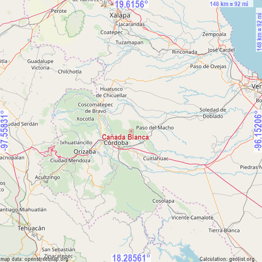
Cañada Blanca GPS coordinates[2]
18° 57' 6.948" North, 96° 51' 18.648" West
| Map corner | latitude | longitude |
|---|---|---|
| Upper-left | 19.6156°, | -97.55831° |
| Center: | 18.95193°, | -96.85518° |
| Lower-right: | 18.28561°, | -96.15206° |
| Map W x H: | 147.9×147.9 km | = 91.9×91.9mi |
| max Lat: | 32.7° ⇑65.8% North |
| Cañada Blanca: | 18.95193° |
| min Lat: | ⇓34.2% South 14.53588° |
| min Long | Cañada Blanca | max Long |
| -117.105° | -96.85518° | -86.73105° |
| W 76.6%⇐ | ⇒23.4% E |
Elevation
Elevation of Cañada Blanca is 769 m = 2523 ft, and this is 484.7 m = 1590 ft below average elevation for this country.
| Max E: |
3497 m = 11473 ft | 63.7% |
| Avg. | 1253.7 m = 4113 ft | |
| Cañada Blanca | 769 m = 2523 ft | |
Min E: |
-1 m = -3 ft | 36.3% |
See also: Mexico elevation on elevation.city.
Geographical zone
Cañada Blanca is located in North Torrid zone (between Equator and Tropic of Cancer). Distance of this Northern Tropic circle is 498.7 km =309.9 mi to North.| Distance of | km | miles | from Cañada Blanca |
|---|---|---|---|
| North Pole | 7899.8 | 4908.7 | to North |
| Arctic Circle | 5293.9 | 3289.5 | to North |
| Tropic Cancer | 498.7 | 309.9 | to North |
| Equator | 2107.3 | 1309.4 | to South |


Nearby cities:
15 places around Cañada Blanca: (largest is in red/bold)
• Berlín
8 km =5 mi,  241°
241°
• Cerro Azul
8.3 km =5.2 mi,  45°
45°
• Ejido los Naranjos
1.7 km =1.1 mi,  349°
349°
• El Porvenir
8.2 km =5.1 mi,  245°
245°
• Ignacio Zaragoza
4.3 km =2.7 mi,  150°
150°
• La Charca
5 km =3.1 mi,  69°
69°
• Miguel Aguilar
4.9 km =3 mi, 254°
• Paraje Nuevo
8.1 km =5 mi,  184°
184°
• Plan de Ayala
2.9 km =1.8 mi,  296°
296°
• Potrero Viejo
8.4 km =5.2 mi,  171°
171°
• Progreso
5.9 km =3.7 mi,  27°
27°
• San José Tenejapa
7.2 km =4.5 mi,  10°
10°
• San Matías
8.4 km =5.2 mi, 239°
• San Rafael Río Seco
8.9 km =5.5 mi,  198°
198°
• Álvaro Obregón
6.3 km =3.9 mi, 346°
Sources, notices
• [Note1] Compared only with cities in Mexico existing in our database
• [Src1] Map data: © OpenStreetMap contributors (CC-BY-SA)
• [Src2] Other city data from geonames.org with taken over terms of usage.
• [Src3] Geographical zone / Annual Mean Temperature by Robert A. Rohde @ Wikipedia
