Cacahuatal geodata
Cacahuatal (Veracruz) is a populated place; located in Mexico in America/Mexico_City (GMT-6) time zone. With population of 1,609 people, there are 5377 cities with bigger population in this country. Compared to other cities in Mexico, 68.2% of cities are located further ↑North; 76.8% of cities are located further ←West and 67.2% of cities have higher elevation than Cacahuatal. Note1


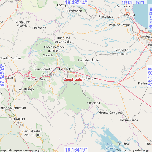
Cacahuatal GPS coordinates[2]
18° 49' 51.528" North, 96° 50' 30.912" West
| Map corner | latitude | longitude |
|---|---|---|
| Upper-left | 19.49514°, | -97.54505° |
| Center: | 18.83098°, | -96.84192° |
| Lower-right: | 18.16419°, | -96.1388° |
| Map W x H: | 148×148 km | = 92×92mi |
| max Lat: | 32.7° ⇑68.2% North |
| Cacahuatal: | 18.83098° |
| min Lat: | ⇓31.8% South 14.53588° |
| min Long | Cacahuatal | max Long |
| -117.105° | -96.84192° | -86.73105° |
| W 76.8%⇐ | ⇒23.2% E |
Elevation
Elevation of Cacahuatal is 577 m = 1893 ft, and this is 676.7 m = 2220 ft below average elevation for this country.
| Max E: |
3497 m = 11473 ft | 67.2% |
| Avg. | 1253.7 m = 4113 ft | |
| Cacahuatal | 577 m = 1893 ft | |
Min E: |
-1 m = -3 ft | 32.8% |
See also: Mexico elevation on elevation.city.
Geographical zone
Cacahuatal is located in North Torrid zone (between Equator and Tropic of Cancer). Distance of this Northern Tropic circle is 512.1 km =318.2 mi to North.| Distance of | km | miles | from Cacahuatal |
|---|---|---|---|
| North Pole | 7913.3 | 4917.1 | to North |
| Arctic Circle | 5307.4 | 3297.9 | to North |
| Tropic Cancer | 512.1 | 318.2 | to North |
| Equator | 2093.8 | 1301 | to South |


Nearby cities:
15 places around Cacahuatal: (largest is in red/bold)
• Adolfo López Mateos (San José de Enmedio)
5.7 km =3.5 mi,  112°
112°
• Barrio Guadalupe
5.9 km =3.7 mi,  214°
214°
• El Otate
6.4 km =4 mi,  240°
240°
• Ex-hacienda la Concepción
2.7 km =1.7 mi,  43°
43°
• General Alatriste (San Joaquín)
5.2 km =3.2 mi,  78°
78°
• General Francisco Paz (El Poblado)
4 km =2.5 mi,  71°
71°
• General Juan José Baz (San José del Corral)
2.7 km =1.7 mi, 112°
• La Loma de Guadalupe
2.9 km =1.8 mi,  130°
130°
• Manuel León
4 km =2.5 mi,  309°
309°
• Paraje Nuevo
5.7 km =3.5 mi,  339°
339°
• Potrero Viejo
5.2 km =3.2 mi,  358°
358°
• San Antonio Fraternidad
1.5 km =0.9 mi,  5°
5°
• San Rafael Río Seco
6.5 km =4 mi,  320°
320°
• Venta Parada
2.4 km =1.5 mi, 340°
• Yanga
4.6 km =2.9 mi,  87°
87°
Sources, notices
• [Note1] Compared only with cities in Mexico existing in our database
• [Src1] Map data: © OpenStreetMap contributors (CC-BY-SA)
• [Src2] Other city data from geonames.org with taken over terms of usage.
• [Src3] Geographical zone / Annual Mean Temperature by Robert A. Rohde @ Wikipedia
